
 Having crossed half the Pacific, it was time to earn some money again. So we left Bosun Bird on dry land, at a small shipyard, the Chantier Naval des Iles, on the island of Raiatea, about 120 miles west of Tahiti. After a hectic and exciting two years working for the Canadian High Commission in Islamabad, Pakistan, we returned and put Bosun Bird back in the water in June 2009, just in time for the annual Heiva (formerly Bastille Day) festivities in July.
We got back into the swing of things with a ten-day sail within the huge figure-of-eight reef that encloses both Raiatea and the smaller Tahaa. These were safe and familiar waters that we’d cruised 23 years ago on our previous boat Tarka the Otter, and more recently, before taking Bosun Bird out of the water. We re-learned the boat’s special quirks, opened long-closed lockers and tried to remember what we needed to buy and prepare before an ocean passage, all the while anchoring in beautiful spots off deserted motus on the reef and in green valleys cut deep into these lush, high islands. We swam every day, several times with manta rays, and more mundanely to check that our anchor was not likely to foul a coral head and jam itself. On the reef the anchorages were shallow – four or five metres, over pure white sand – but in the bays of the main island they were often 20 metres or more, which had Jenny complaining every morning, as it was her duty to haul up the anchor (and 30 metres of chain). On the western side of Tahaa we could look out over the encircling reef to the distinctive profile of Bora Bora, a great wedge of a mountain rising from the sea twenty miles away; the sunsets behind it were invariably spectacular.
We also re-learned the intricacies of coral navigation: various shades of blue indicating a safe passage four or more metres deep, light blue a possible anchorage over sand, white too shallow, and – of course – brown, orange and black indicating coral. Some of the more “iffy” channels not marked in the eighties were now well-indicated with posts, beacons and buoys and cruising guide books now invariably depended on GPS for reference (it did not exist in the mid-eighties). There were probably more boats around than twenty-five years ago, but not by a very large margin; what did strike us was that the average size of sailboat was now much greater and there were a lot more catamarans in evidence. Overall, tourism in French Polynesia was taking a beating from the recession; at several of the USD $1000-a-night resorts there was simply no-one in evidence at all, no lights at night.
 For the Heiva there are outrigger races, agricultural contests, stone-lifting (!) competitions, and – most popular with the visitors – competitive dancing and singing. Every night you could hear the beating of drums and singing as even the smallest of villages prepared their entries. We went to watch a practice session at Haamene, on Tahaa: the Big Men (who are VERY big hereabouts) doing the drumming for the more warlike pieces, the Big Women the singing, and the young people the dancing. The dancing is very sensual on the women’s part – much wiggling of bottoms, some of it at fantastic speeds; it was a world away from Pakistan! You could quite see why the crew of the Bounty, faced with a nine-month passage back to wet and cold England under tyrannical Captain Bligh, much preferred to stay on and get to know the local vahines.
 With a big swell running from some distant storm in the Southern Ocean, we had a pleasant sail over to Bora Bora, the most “exclusive” of all the islands of Polynesia. It was made famous after James Michener was briefly stationed here in WW2, and later wrote Tales of the South Pacific, on which the musical South Pacific is based. “The” place to be seen now is Bloody Mary’s restaurant – there is a painted board outside listing all sorts of distinguished guests from Cameron Diaz to John Travolta and Danny de Vito, but the price-list was a little on the expensive side for us – we were by now on a quite pleasant daily ration of baguettes and French pate or cheese – so we did not ask for our names to be added this time. We spent some time anchored off the Bora Bora Yacht Club (a misnomer; it’s just a restaurant; in the eighties it was a real club and we signed the Livre d’Or, but that is long-forgotten) and, more enjoyably, nearly a week on shallow sand-shelves just inside the barrier reef, on our own.
The main “town” on Bora Bora is now daily jammed with expensive 4 by 4s, this on an island where there is only one twenty kilometre round-the-island road. We looked for an old monument we recalled, to the famous French sailor Alain Gerbault and his yacht Firecrest, but it was obscured by the grandstand that had been set up for the Heiva dances; one day a 700-passenger cruise ship came in and swamped the entire place.
 From Bora Bora it was a 480-mile downwind sail to Aitutaki, in the Cook Islands, which took us five days. There was a large sea running and the wind was squally, so we got quite wet; also, although we were only going a hundred miles or so further south, the climate became distinctly cooler.
Aitutaki is another classic coral atoll: a “high” main island, with a surrounding reef, between one mile and ten miles out from the main island – in this case forming a lagoon six miles by four miles. The complication here is that, unlike at Bora Bora, there is no natural entrance through the reef. In WW2 US Seabees blasted a 1000 metre long passage, barely 12 metres wide, through to the main settlement; in one place it is, at high tide, less than 2 metres deep. This meant timing our passage for a rising tide (in case we got stuck, we would in theory be lifted off), just short of high tide (which occurs twice every 24-hours).
 Our entry was fraught, largely because our tide tables disagreed with those of a yacht inside the passage, with which we were in radio contact: we ended up going in a lot earlier than we should have. For the first 300 metres we battled a fierce outgoing current, spending several minutes simply motionless, at full revs – and with no room to turn around. Once inside, the situation is scarcely better, with very few spots over two metres deep, but we were able with some relief to put our anchor down and tie the stern to two palm trees on shore, with a good eighteen inches under our (4ft 6in) keel.
The total population of Aitutaki, which is the second-most-important of the Cooks (after Rarotonga) is about 1800, mostly spread very thinly along the road that fringes the main island. Downtown consists of two small banks, a post office, a small shop and a magnificent church that dates from 1821 (established by John Williams of the London Missionary Society, later eaten by the Big Nambas of the New Hebrides). It’s a twenty minute walk to Spider’s, the Internet cafe, and there are a few other small shops scattered around; overlooking the harbour, in the old banana-packing shed, is the Blue Nun, a disco/restaurant that comes dramatically to life twice a week but which is otherwise deserted.
 People were very friendly and the whole place was extremely laid-back. We didn’t do too much. One afternoon we went to the final of the Island Rugby championship (astoundingly, the place supports nine fifteen-a-side teams) where the Tautu Blues came out victorious in a surprisingly skilful game. We attended church twice, largely for the very beautiful hymn-singing, but also because that is about the only activity allowed on Sundays. The women wore bright floral Mother Hubbards (introduced by the missionaries), with straw hats decorated with flowers, and many of the men white suits, which made them look like ice-cream salesmen. Nearly all of the singing was in Cook Island Maori, but now and again you could recognize a traditional hymn from John Wesley – and even figure out what the words would be in English – “Tabu, tabu, tabu”, Holy, Holy, Holy.
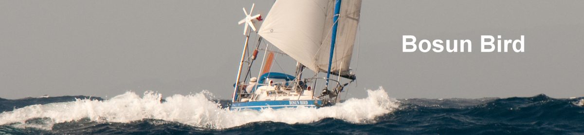
 We rented bikes and rode around the island and one day climbed to the highest peak – a mere 300 metres, but you get puffed out after spending so much time immobile on the boat. Another day we took a cruise inside the lagoon (too shallow for our boat – we had to go commercially) and had some amazing snorkeling, with visibility over 30 metres and very abundant fish life; on one of the remoter motus we found nesting Bosun Birds in massive numbers, very tame and apparently helpless, easy prey to the large Frigate Birds that were cruising ominously.
One night there was considerable mayhem in the yachting community when an unusual westerly wind came in and several boats (including ourselves) dragged their anchors. We spent several hours of a wet and windy dark night re-laying anchors and keeping Bosun Bird off the beach, and slept most of the next day. A day or two later there was more excitement when two boats went firmly aground in the entrance passage as they were trying to leave; Camelot and Gucci were stuck for more than an hour. We watched all this with some trepidation, as – of course – we would need to leave by the same route.
After a two-week stay, the weather forecast wasn’t great but we needed to be moving on because we would not have any more good, high tides in daylight for another fortnight – the pre-requisite for getting out safely. So we edged our way out very carefully and slowly, just grazing the sandy bottom twice. Our next destination was Palmerston atoll, 200 miles to the WNW and another of the Cook Islands (there are fifteen islands in the whole group, but they are spread across a territory larger than Europe, and only Rarotonga has more than a couple of small villages). We had a fast sail, and by dawn two days out were edging our way around the southern edge of the atoll. Having GPS makes arrivals such as this a lot easier than they were twenty years ago, when – relying on sun sights – we would have to heave to well short of our destination at night and only edge forward very carefully in the daytime. The motus or small islands that are found on the rim of these atolls are visible, at most, seven miles away, and only if they have a good bunch of coconut trees; much of the circumference of the atoll may be right at sea level and only visible when the sea breaks heavily on it.
 Palmerston is another classic coral atoll, about six miles by four, with half a dozen motus, one of them inhabited, sprinkled around its rim; the inner lagoon is shallow – maybe a couple of metres, in every imaginable shade of blue and white – and sprinkled with dangerous coral heads. It only has a couple of narrow, encumbered passages though the coral, so visiting boats must anchor on the outside, usually on the western rim where the atoll offers protection from the prevailing easterly winds. The anchorage is precarious: the bottom is coral, which affords a poor grip for anchors and/or jams them on the bottom, and the reef drops off very quickly, leaving only a very narrow shelf on which to anchor; if the wind shifts much from the usual easterlies you need to get out immediately. To ease the situation, the locals have placed half a dozen mooring buoys, anchored to coral heads with chain, but even so many yachts have been lost here.
This is, however, quite a unique place, and we were anxious to make a stop, however short. The population of the atoll is about fifty, including 23 children, and they are all – without exception, descended from a colourful 19th century sea captain called William Marsters, who arrived here in 1860 with three Polynesian wives. Marsters devised strict land ownership and inter-marriage rules and these prevail still: the one-mile long island is divided into three segments, with each occupied by the descendants of Marsters and – respectively – one of his three wives; the “middle” family is traditionally the dominant one.
 Yachts are accorded a warm welcome (no airstrip and the supply ship comes in only once every three or four months), with families taking it in turns to host them. There is some competition over the hosting (in fact there is a surprising amount of local politics for a place so small), with launches racing out to be the first to “bag” an incoming yacht. We were hosted by Tere Marsters and his wife Yvonne; Tere is the island Secretary or administrator and possibly the most educated man on the island (several years in Rarotonga, then Australia, several as a Cook Islands Christian Church pastor). After guiding us a to a mooring and summoning the various officials that needed to visit us (much job creation here – the island “government”, run by Tere, employs fifteen people, which is half the adult population) Tere ran us in by launch through the terrifying “Boat Passage” (zigzagging, no more than 20 centimetres deep, and with an 8-knot outgoing current) and took us to lunch at the beautiful home that he is constructing. This was shipped in as a kit – he was having some problems with the assembly…. The main dish was parrot fish, which is the island staple, but knowing that fruit and vegetables are in short supply, we had brought a stock of tomatoes and papayas from Aiututaki, which were much appreciated.
 We spent the rest of the day strolling around the tiny island, covered almost entirely with coconut palms but with some very ancient mahoganies at the centre of the motu as well. There is a one-room school, where the children follow an American correspondence scheme, and which has a tennis court and volleyball court; a generating station supplies power twelve hours a day; there is a modern, small church financed by the Marsters community overseas (they stick together wherever they are – the eighteen Marsters family members in Melbourne even have their own Rugby team). There is one old building from “Father”s time, constructed with timbers from a wrecked sailing ship; the church bell is from another such wreck, of HMS Thistle. One family was busy filleting parrot fish: parrot fish fillets are the island’s only export; although their meat fetches a good price, it is a precarious business, with the ship coming so infrequently, and having limited freezing capacity. Cyclones pass here quite often; Tere recounted that last year things looked so bad for a while that he was about to give the traditional and time-honoured order to people to lash themselves to trees lest they be washed away, but the storm had veered away at the last minute.
 “Father” long ago decreed that English – not Maori – was to be the language of his descendants, and this tradition persists, somewhat to the displeasure of central government in Rarotonga, one senses. Like most Cook islanders, the people are devoutly religious, but we early on understood that it was not politic to point out the contradiction between William Marsters’ patriarchal dictates and his having three wives.
This was an utterly beautiful, ostensibly paradisiacal place, far removed from so many of the world’s worries and troubles – and the Marsters seemed to sense they have something special; although Rarotonga has offered repeatedly, they will not accept an airstrip (or cruise ships for that matter). We were sadder to leave here – after only 24 hours, with adverse weather threatening – that we had been virtually anywhere. We guessed somehow – there were hints here and there – that things were not as idyllic as appeared at first sight, but it would have been fascinating to really spend a lot more time here and see whether the Marsters really had found self sufficiency and happiness.
We had a rough ride westwards, with the wind steadily building up to near-gale and gale force, for an unremitting four days. The direction was favourable – from astern – but we were reduced to dousing the mainsail completely and running downwind with only our tiny staysail (about 3 square metres) flying. The seas built rapidly and the motion became very violent. When it’s like this on Bosun Bird, the noise is indescribable – shrieking and howling in the rigging, a clattering of blocks should we veer towards gybeing, and all sorts of unidentifiable creaks and bangs below as the interior works and things get thrown around. You need to be hanging on with at least one hand at all times, and sleeping is very difficult as you are thrown first one way, then the other. At times like this Jenny prefers to try to sleep on the floor, where there is marginally less motion, rather than on her bunk.
The combination of high winds and building seas, with the wind almost dead astern, also makes it difficult for our self-steering to function properly, so for most of our 3-hour watches over this period we were hand-steering. This is dizzily hypnotic at night, as your eyes are glued to the red-lit compass card that sways around, one hand on the tiller, the other on a hand-hold; it’s also quite tiring. But it does mean you can’t turn around to look at the size of the waves coming from behind, which is probably just as well; these break with a noise that sounds like a freight train passing; about one in fifty (once an hour if its rough) foam right into the cockpit, just when you were starting to dry out from the last one.
 We had intended to stop at Beveridge Reef, a mid-ocean atoll with no drying land, but the prospect of searching for its narrow entrance in these seas and winds was not tempting. Similarly, we sped on past the tiny island nation of Niue (the world’s smallest country – pop 1200): it was blowing thirty knots, the night was foul and we knew the anchorage was little better than Palmerston’s. Six days out, with the moon now in its last quarter, and a GPS-course carefully laid out, we made out to port the low dark bulk of the main island of Vavau, part of Tonga. Putting the brakes on, in a sailboat is difficult: we reduced sail to an absolute minimum so as to avoid having to enter in the dark, and timed it just right, so that we were off the welcome and aptly-named Port Refuge on a blustery red dawn morning.
Vavau is an archipelago of mainly deserted, low-lying wooded islands with a maze of inner, well-protected waterways and one small town, Neiafu. It’s a cruising paradise, and many boats come up from NZ and Australia just to spend a season here. As we ghosted ever so gently in, the sky now grey, a pair of giant humpback whales, with a tiny calf between them, surfaced only fifty metres away from us: quite awe-inspiring as they noisily took breath, gently submerged, only to reappear on our other side.
 We moored off the township of Neiafu. This isn’t exactly Manhattan, but there are small shops, a few restaurants and a very active community of semi-permanent yachties (with all the accompanying politics: an American single-hander we met in Aitutaki has now earned himself the sobriquet Freeloading Bob). There is a daily yachties’ net on the VHF radio at 08:30 run by an expat American, happy hours at the bars, quiz night at Tonga Bob’s Taco Place and – more positively – there had recently been a series of events organized by the foreign yachts to raise funds for the survivors of a terrible ferry disaster that struck the kingdom two weeks earlier (over 70 drowned).
 First we wrestled with a perennial problem involving our diesel’s seawater pump, that had plagued us for years, and that means a constant dribble of seawater into the bilge; this involved extracting a screw from a hole in which it was very firmly lodged – a surprisingly difficult job that frustrated Tonga’s Best until we found a dilapidated old car workshop on the hillside, surrounded by rusting car wrecks. A combination of sledgehammer, blowtorch and the physical efforts of two very large Tongans eventually did the job, while mangling a fine piece of stainless that we had been hoping to save. After a few days, we then set off for a three-week cruise around the Vavau archipelago.
This is a maze of low, wooded islands, mostly uninhabited, that provide sheltered water and short distances between anchorages – just as well, as the weather continued to be unusually blustery, with winds in the 20 to 30 knot range almost every day (you would hope for 10 to 15…..). We swam most days, although they water is significantly cooler than in French Polynesia, bushwhacked in search of wild fruit, collected shells. On the western edge of the archipelago we spent several hours dodging more humpback whales as they breached, flapped their enormous pectoral fins in the air, and generally enjoyed making an exhibition of themselves. When we were last here, in the eighties, there were no whales; it is heartening to know that the humpback population has now increased and that they are returning to waters from which whalers drove them away nearly a hundred years ago. There are one or two small villages in the outer islands; none have electricity, so the nights are dark; but they all have three or four churches of different denominations and sometimes you can hear hymn singing rolling out as early as 06;00 a.m., before it’s even light (you have to wonder at the 200 people of Hunga building six churches, rather than have electricity or running water, but there you go…)..
 Back in Neiafu, the yacht population had almost doubled by the time we returned: this was the peak season as boats start flooding in from the eastern Pacific, and begin to contemplate Spring passages to NZ and Australia. The expat (“palangi”) scene was frenetic, with weekly yacht races, fund raising Tongan feasts, special sessions to watch Tri-Nations rugby broadcast from NZ and Australia, and so on. But we were not sure we’d like to exile ourselves here permanently: it was also a cliquish, closed community that seemed to have relatively little interaction with “real” Tongans, and there was quite a lot of petty politics and jealousies as the foreign-run restaurants and bars competed for the yachties’ business (including sabotaging each other’s commercials on the daily radio net).
With no AM or FM radio and only very occasional internet access, we were completely out of touch with international events; Pakistan could not seem further away. There was a daily newspaper in English in the Cooks: the day we left the front page banner headline was “Raro sewage summit postponed again”, which just about says it all.
Our next destination was the Tongan island of Niuatoputapu, which sits in isolation between Vavau and Samoa, about 175 miles to the north. This was a pleasant two-day sail, made interesting by several sightings of humpback whales.
, Niuatoputapu, Tonga") NTT (which cruisers call New Potatoes, but the locals don’t like that) is an island about 4 miles by two, with a protected lagoon anchorage on one side, and hills rising to about 250 metres. There are three small villages, each with a population of about 200, joined by a dirt track. There’s just one small shop – as usual, Chinese owned, in one room, and stocking mainly NZ corned beef. Normally there is a ship once every three or four months, but none was now expected until “next year”, following the disaster in which one of Tonga’s two ferry boats had sunk with heavy loss of life. There is an airstrip, but the little Cessna that is supposed to come in occasionally had stopped flying too, because the island’s electronic direction-finding beacon was down and it required a technician to be flown in to fix it….could be a while!. Pretty much everyone is 99% self-sufficient in these circumstances – all that needs to be imported is fuel for the two or three small fishing boats, and flour/sugar. There’s one local export, run by a group of Chinese; the revolting-looking Beche de Mer (sea slug), which grows abundantly in the lagoon and which is greatly prized as an aphrodisiac in China; we thought this once huge business had died out a hundred years ago, but a group of earnest men were boiling up dozens of the creatures in a vast and foul-smelling vat on the beach.
NTT (which cruisers call New Potatoes, but the locals don’t like that) is an island about 4 miles by two, with a protected lagoon anchorage on one side, and hills rising to about 250 metres. There are three small villages, each with a population of about 200, joined by a dirt track. There’s just one small shop – as usual, Chinese owned, in one room, and stocking mainly NZ corned beef. Normally there is a ship once every three or four months, but none was now expected until “next year”, following the disaster in which one of Tonga’s two ferry boats had sunk with heavy loss of life. There is an airstrip, but the little Cessna that is supposed to come in occasionally had stopped flying too, because the island’s electronic direction-finding beacon was down and it required a technician to be flown in to fix it….could be a while!. Pretty much everyone is 99% self-sufficient in these circumstances – all that needs to be imported is fuel for the two or three small fishing boats, and flour/sugar. There’s one local export, run by a group of Chinese; the revolting-looking Beche de Mer (sea slug), which grows abundantly in the lagoon and which is greatly prized as an aphrodisiac in China; we thought this once huge business had died out a hundred years ago, but a group of earnest men were boiling up dozens of the creatures in a vast and foul-smelling vat on the beach.
We spent nearly a week here: one of our favourite stops anywhere. One day we walked the 8km (deserted) windward beach: all sorts of interesting flotsam, some from as faraway as Chile and Peru. Another day we hacked or way up to the top of the main ridge: dense rainforest, with great views on the top. There was a local lady called Sia who had taken it upon herself to “look after” the cruisers, so one evening she organized a pig roast in the garden of her home, with the crew of the six or seven boats that were now in bringing cake and so on.
 Another day, we arranged with Sia’s husband Nico to take us over to the neighbouring island of Tifahi – a spectacular volcanic cone reached after a very wet and bumpy ride of five or six miles across the open ocean. There was no decent anchorage here, so we went in Nico’s open launch. Here on Tifahi about fifty people live in a village perched precariously about one quarter of the way up the 700 metre high mountain, living on fishing and – above all – cultivation of the much sough-after kava root from which an unenticing traditional brew is made – looks and tastes like ditch water and leaves your mouth mildly numb; a men-only activity. The trek up the mountain was a strenuous three-hour climb through ever denser rainforest; again, fantastic views, but we doubted the story that on clear days you could see Samoa (160 miles away). We gathered an entire stalk of bananas on this trek (about 100 individual bananas), which stood us in good stead – a dousing in salt water to kill bugs and hasten ripening, and then the only problem is that they all become ripe at the same time.
One day, into the anchorage sailed Mahina Tiare, skippered by John and Amanda Neal. Thirty years ago John wrote a book called Log of the Mahina, in which he recounted his adventures in the South Pacific as a young man on his Vega 27; this had been an inspiration to us, giving us the confidence to buy a Vega ourselves (our last boat) and we also attended a seminar John gave in Seattle in 1986. We’d later used notes of his in Chile, as well. It was fun to catch up. John and Amanda have a full-time business taking paying passengers/crew on their boat (which is consequently a lot larger and more comfortable than the original Mahina….).
When the weather looked good we upped anchor and were off again, this time almost due west. This was one of our quietest passages yet, with the wind in a very comfortable 10 to 15 knot range (thus far this year things had been unusually blustery, even unpleasant). Some careful navigation was needed as we approached the first outliers of the Fiji group, which are a full hundred miles east of the two big islands. Two weeks earlier the radio waves had all been abuzz when a Dutch sailor (whom we knew faintly) put his boat on a reef at Mago island, about fifty miles south of where we were now. The good news for him was that the locals were very friendly and helpful (unlike in Bligh’s time, when the just-deposed captain feared to land here on account of cannibals) and after massive efforts they were able to float him off again; the island is owned by Mel Gibson, and Mel’s chef was in attendance, and looked after him very well!
 Approaching the big island of Vanua Levu, we crossed the line of longitude 180 – the obverse of the Greenwich meridian, and thus entered the eastern hemisphere; our GPS seamlessly ticked over from 179.59 degrees west to 179.59 east.
We made our formal entry at Savu Savu, the main port on Vanua Levu, which is the smaller of Fiji’s two main islands. It’s a bustling little market town of about 5000, with a large Indo-Fjian presence; Bollywood music blares out from the shops and it was strange for us to overhear many snatches of Hindi/Urdu, which we recognized from our stint in Pakistan.
 When we were checking in, the customs officer made a passing reference to “the tsunami”. It was only then we started to learn the full horror of what had occurred just after we had left NTT. The island was the closest inhabited spot to the epicentre and two of the three communities we’d come to know were effectively wiped out; access was of course very difficult but we understood there were at least 20 dead on NTT, and from an aerial photo displayed in the Fiji Times we could tell that Sia’s home and the Chinese shop had simply disappeared. At sea we had noticed nothing. Later we were in e-mail touch with three yachts who miraculously had pulled up their anchors and left only an hour before the waves came in. They reported the astounding sight of the outer barrier reef becoming completely exposed and most of the island below the ridge apparently engulfed. There was no time to warn Samoa, and there was heavy loss of life there, but in Tahiti (1200 miles) they activated a warning mechanism and the entire harbour was evacuated for several hours while they waited to see if the waves would come.
 From Savu Savu we worked our way west and south, first to the beautiful and wild island of Yandua, at the eastern edge of Bligh Water (first explored by the infamously deposed captain on his way in an open boat to Timor) and then, all in protected waters, around the top and western edge of Fiji’s other big island, Viti Levu. We restocked in the sugar port of Lautoka, enjoying several curries, and then headed out to the resort island of Malolo Lai-Lai.
 Here the cruising fleet was slowly gathering. Cyclone season was looming, and it was time to start heading out of the warm waters that cyclones need, and to a more secure port, either in New Zealand or Australia. A kind of psychosis gripped the anchorage: every day cruisers exchanged with each other their latest assessments of the weather and debated when would be the best time to set off. One German cruiser had engaged a professional weather router – Dame Ellen MacArthur’s, he boasted – and assured us it would be suicidal to set off right now. The first few days would not be a problem, whenever we ;left: we were still firmly in the area dominated by the SE trade winds. But as we neared the halfway mark to New Zealand, we knew things would become a lot more variable, with fronts bringing SW winds backing to the NW. The trick was to accept that you would experience at least one front, possibly with some strong wind, but get it over with while you were still at some distance from the NZ coast, so as to be able to approach the Bay of Islands with a favourable wind slant from the NW.
 Easier said than done, of course. NZ weather guru Bob McDavitt would announce in his regular “Bobograms” that “next weekend will be good time to arrive in Northland”, but impractical when you are 1100 miles away and capable of only 100 miles a day. But on November 2nd things looked reasonable; we upped the anchor at dawn and two hours later were sailing through Fiji’s outer barrier reef and into the open Pacific again.
The passage was, after the first few days when we were close reaching into 20 to 25 knots, a slow one. We reached the recommended position: 300 miles due north of New Zealand’s North Cape, at the recommended time. But light to moderate SW winds persisted as we crept, close hauled, closer and closer to NZ. And, to add to our woes, a west-setting current grew stronger and stronger, sweeping us away to Australia.
 The powerful light of Cape Brett finally came into view late one hazy evening as the wind finally became favourable – westerly at 20 knots. We reduced sail, edged our way carefully into the Bay of Islands on a moonless night and then meandered for several hours, waiting for daylight. An hour before dawn, one or two light fishing skiffs sped out and past us. Mist hung over the water as the sun rose, but by six it was clear. With a considerable sense of relief we motored our way upriver to the Quarantine dock at Opua marina, 15 days out from Fiji.
More: In New Zealand