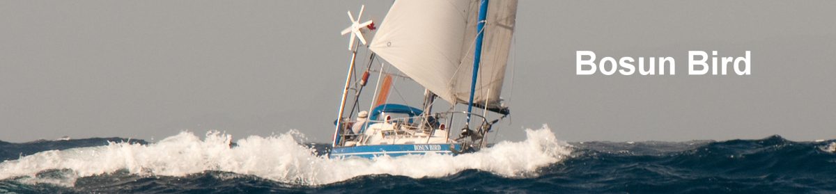
Last summer (2021), engine woes curtailed Bosun Bird’s plans, but this time (2022) we had a brand-new Beta 25 in place, so we set off in late May for points north. As usual, we set no ETA, and had only an Estimated Destination, but the cruise would eventually become a circumnavigation of Vancouver Island. This was a voyage we’d undertaken once before, back in 1984.

North up the Inside
 Familiar anchorages in the Gulf Islands of British Columbia (BC) led us to the first of many gateways on our voyage: the constriction at Dodd Narrows, where at maximum ebb or flood tides, the current runs at nine knots. We transited at slack; the only issue was, as usual, other traffic with the same plan, in this case a slow-moving tug and barge.
 Next day our crossing of the Strait of Georgia was largely windless, allowing only for intermittent sailing in NW zephyrs. A day of heavy rain and poor visibility kept us in Bargain Bay, but once the rain eased off, we took advantage of the SE winds to run north up Malaspina Strait, between Texada Island and the BC mainland. With the wind picking up to 30+ knots we turned for shelter into the unappealingly named haven of Blubber Bay, on the very tip of Texada; this was so-named because it was once used for rendering whales that were hunted in the Strait.
The blustery southerly continued next day and we had what would turn out to be our fastest sailing of the summer, downwind to Refuge Cove. This is the “mall” for visitors to popular Desolation Sound: a small set of floats, an old shop and a few houses crammed into a corner of the bay, accessible only by sea. As at so many popular stops, we found that the best anchorage space was taken up by unoccupied mooring buoys. Some excitement ensued when the captain – by sheer force (?!) – snapped one of our wooden oars while returning from the shop to the relatively distant Bosun Bird.


From Refuge, we faced a choice of tidal narrows: the triple-whammy of Yucultas-Gillard-Dent, or a more separated series, beginning with Hole-in-the-Wall. We opted for the latter, spending a tranquil night at Florence Cove as we waited for slack.  We shared the anchorage with the Columbia III – the last of the famous mission vessels that plied the coast as hospital ships for much of the 20th century. Built in 1956 but upgraded and restored, she is now an expedition ship, catering above all to kayakers.
The aptly-named Hole-in-the-Wall (maximum current 12 knots) was passed carefully but uneventfully, and we lingered in the always quiet Octopus Islands before transiting Okisollo Rapids and – with heavy winds forecast – taking shelter at Owen Bay. BC cruising legend Liv Kennedy grew up here and her well-illustrated book Coastal Villages has anecdotes of this community in the 1950s and 60s. She tells of ghosts that tread the government dock late at night, of bodies hauled up from the bottom, weighted with chains; and of her friends the Camerons, who simply disappeared from their yacht Drifter, leaving only a hungry cat on board and an up-to-date logbook. Like so many once-thriving places on the coast, Owen Bay is now quiet. There is still a government dock, but the houses in the woods are largely holiday homes that are barely frequented outside the summer months.


It rained and rained – June 2022 was to be a lot wetter than usual, even on this notoriously damp coast – but the long-promised winds did not reach into Owen Bay. Once the downpours steadied to drizzle, we set off through Okisollo’s Upper Rapids, ventured briefly into Johnstone Strait past the Chatham Point light, and then retreated into the channels again, to Cameleon Harbour (that’s no typo: HMS Cameleon was a Royal Navy 17-gun corvette on the Pacific Station, starting in 1861).  We had a few moments of mystery when the engine exhaust briefly turned red, then pink; later investigation of the water strainer revealed that we had inadvertently ingested a red jellyfish, which sadly did not survive the encounter. We sailed in light winds past the formerly popular stop at Shoal Bay. Back in the 1980’s we had patronised the shop here, and pre-COVID they still served beer and ice-cream;
  but it seemed they would be closed this summer (as they have been for the past two), another victim of the pandemic. So the anchor went down in neighbouring Bickley Bay.
Another early start, another set of rapids (Greene Point). It’s easy to become blasé about the succession of rapids that you must transit on this coast. And indeed, at slack water, there is no excitement at all. But if you ever have a chance to see such rapids at their maximum rate, it will give you pause for thought – at Skookumchuck, on the Sunshine Coast, we once saw the 16-knot flood toss a 30m log tree clear into the air.
 For a change, we now turned into the dead end that is Loughborough Inlet. This was heavily logged 30 years ago but is now largely recovered and makes for a scenic diversion from the main drag north and west. We tied up at distinctly tired floats on the south side of Sidney Bay; it looked as though they would probably be swept away in high winds, but the location is well-sheltered. Sidney Bay is the home of Dane Campbell and his artist wife Helen Piddington. Virtually the last of the old-style pioneers in these parts, they homesteaded here starting in 1975; Helen writes (and paints…) about their lives in The Inlet: Memoirs of a Modern Pioneer. Dane’s getting on a bit and Helen’s health is not great, but he told us that his son will take over the operation.
Past the last set of rapids on the inside route (Whirlpool) we anchored at beautiful Althorp Point Cove. From here, the only track onwards is through Johnstone Strait, where the prevailing westerly winds can kick up a nasty chop when opposed to the ebb current – which, at this time of year, with heavy run-off, is near perpetual. So, we listened attentively to the automatic reporting station at Fanny Island, in the center of the Strait. With the westerly at a consistent 20 knots, we put off our departure for a day. When we finally left it was with a rare, light easterly that, with the strong ebb, made for fast progress to Mist Islets, in Port Harvey. This is another of those places that once thrived – and there was a shop and docks for cruisers until three years ago – but now has only a few holiday homes that seem to be visited only infrequently.


 Riding the ebb next day, starting at 04:45, we coasted past the Alaska ferry in the fog, occasionally glimpsing snow low on the hills of Vancouver Island to port, and were pushed past Alert Bay at 7.5 knots. We tied up at the government docks at an old favourite of a stop – Port McNeill – and had our first meal out for weeks, at the Sportsman’s Steak and Pizza House.
  But the captain was fretting; he’d noticed that the exhaust on our new Beta 25 engine seemed strangely wobbly, and he couldn’t stop thinking about it. Next day we unwrapped the fibre insulation on the exhaust and to our horror found it was cracked right through. It had not only been spiling soot but, presumably, odourless and lethal carbon monoxide, possibly for some time.
 Over the years, we have trekked the streets of many a seaside town in search of mechanics with sundry engine specialisations, from Cape Town to the Caribbean coast of Venezuela. It took several climbs of the steep hill behind Port McNeill before we were able to find a cooperative welder who – for cash – fixed up our exhaust, at least for now. So as to minimise the vibration that had presumably caused the crack, we also jury-rigged a sailing turnbuckle, that allowed the exhaust to be tensioned back to the engine. In celebration, we went out that night to Port McNeill’s other fine eatery: Gus’s Pub. Our choice – the food was fine, but the place was crowded and noisy – would later turn out to have been ill-advised.
Around the Top
 We said goodbye to the crew of the next-door boat – Pole Dancer – without summoning up the nerve to ask the origin of their boat name and headed out into Goletas Channel. The course was now nearly due west as we headed for the open Pacific. With the prevailing summer wind and seas coming from that direction, it’s important to take advantage of calms and/or light easterlies to make progress here. That morning – off Port Hardy – we spotted our first Sea Otter. Reintroduced to the west coast in the 1960s after near-extirpation, their territory now increases steadily every year.
 At Bull Harbour, the conventional jumping-off point for the rounding of Cape Scott and the beginning of any sail down the west coast of Vancouver Island, we were disappointed at the signs indicating it was forbidden to land. We recalled a walk, back in 1984, to the magnificent beach on the north shore of Hope Island. But we would need to get up before dawn next morning anyway, so we had an early night. This perfect, calm anchorage is named for the Steller Sea Lion bulls that often frequent it, but this evening it was more peaceable Sea Otters that seemed to be in possession of the place.
The next obstacle is Nawhitti Bar: a relatively wide but shallow (11m) passage between Hope Island to starboard and Vancouver Island to port, after which you are very much in the open Pacific. Problems can and do arise when swells coming in from the open ocean meet a strong ebb tide, in which case dangerous breakers block the entire passage.  The solution is to cross during the last half-hour of the flood (when swell and current are in the same direction) and/or edge very close to the southern shore, behind a patch of kelp-covered reef called Tatnall Reefs, where the depth is even shallower but the swell and current are diminished. Having crossed in the middle of the bar in 1984, we this time tried the Tatnall route, just as dawn broke. It worked, but it would still be two or three hours before we lost uncomfortably choppy seas.
 By 10:30 we were off the great landmark of Cape Scott, the northwesterly tip of Vancouver Island. The red and white buildings of the lighthouse complex were barely visible in trees on top of a low cliff, and we were disappointed that the long-hoped-for northwesterlies did not immediately kick in, but this was a high point all the same. Humpback whales cruised nearby in the oily swell and otters looked up curiously as we passed. In the early afternoon, we threaded our way through an intricate, narrow channel into Sea Otter Cove and tied up with some relief at one of the four hurricane buoys maintained by the Department of Fisheries and Oceans.
At Sea Otter Cove, the crew began to pay the price for our wild night at Gus’s in Port McNeill: a pair of tests in rapid succession confirmed that she had COVID. The symptoms were mild, though, and we spent several days exploring on shore as strong winds lashed the coast outside. On the beach we found not only the remnants of a glass fishing float (a rare find these days) but several large, deflated rubber toys, that had presumably washed ashore here when the Zim Kingston lost several containers overboard near here in October 2021. One day we bushwhacked through low forest to the north-facing Lowrie Bay where we found more interesting debris on its windswept sand beach: a large intact halogen bulb, probably from an Asian squid-fishing boat, used for night fishing.


At almost any time when we looked out, we would see black bears roaming the beaches of Sea Otter Cove, turning over rocks in the hope of finding something tasty.  After one of our sorties, we approached our inflatable dinghy from about 30m away, and realised a very large black bear was walking towards it from the opposite direction, at about the same distance, a tuft of grass in his jaws. Presumably, we would be more tasty than the grass. We obeyed the conventional wisdom: we tried to make ourselves look large, did not turn away, talked to him. But he kept coming. Throwing caution to the winds – who knows how long we might have to wait for him to lose interest? – we rushed for the dinghy and launched it just as he reached the tree to which the dinghy painter had been tied. He watched us splash out to Bosun Bird, fired with adrenaline.
We’d seen very few sailboats so far – and wouldn’t see many more – but at Sea Otter Cove it was a pleasure to meet Greg and Connie aboard their large, self-built aluminum yacht Mira, out of Comox. We’d catch up with them two or three times more, always unexpectedly, always a pleasure: such is the cruising life.
One night it blew 36 knots (so said Mira, who have an anemometer) but no swell reached into the cove and the heavy mooring buoy held solid. Once the winds were steadier and the sun was out again, we headed on to the first of the five large Sounds (inlets) that cut into the west coast of Vancouver Island: Quatsino.


Quatsino Sound
 For once, we had steady and favourable winds for the run in sunshine down to the Kains Island light, that marks the entrance to Quatsino. The knowledge that was no land to starboard until Japan was oddly exhilarating.
 Winter Harbour is a tiny community a few miles inside the Sound, on a well-protected inlet of its own. Last time we had been here, in 1984, it had been crammed with 150+ salmon trollers. Now there were just a few sports fishing boats; the processing sheds of the BC Packers company were abandoned, closed up. The population in summer is maybe 50 – sports-fishers, people from Port Hardy (a two-hour drive on a rough logging road) with summer homes – but it goes down to two or three in winter; the school closed long ago.
 Most importantly for us, there was still a post office, albeit with very reduced opening hours. Although we had had our exhaust re-welded, we were worried that it might well fail again; so, using the town pay phone (no cell signal here…) we ordered a spare, to be made up in Sidney (BC) and then mailed to us.
Canada Post’s Express Delivery service was not quite as Express as we might have hoped. So, we spent some time getting to know Winter Harbour and making a leisurely cruise up and down the relatively-unvisited Sound.
Like several other settlements, Winter Harbour is centered on a boardwalk, about 2km long in this case. There is a single shop that is open in the afternoons only (in summer), a fuel dock and a garbage drop; fresh water is available. Rafts of Sea Otters (each holding “hands” with another) drift in and out with the tide, dispersing only when the town’s resident Orca comes in for a cruise; black bears meander along the tide line. What more could anyone want in a town?


 An exceptionally strong high pressure area over BC (it was shaping up as an odd summer…) meant for unusual, strong outflow winds in Quatsino Sound, but the fetch is limited so we had little trouble reaching our first anchorage up the Sound, at Koprino Harbour. These days there’s a cruising guide to almost everywhere, even these remote waters, but you have to conclude that the authors of one of the guides that we were using had made only a very cursory visit.
  Soundings were manifestly incorrect and we found ourselves in a rather more “snug” corner at East Cove (i,e. close to shore) than we would have liked; we ran a line to a tree to keep us from drifting into deep water.
Next up was Pamphlet Cove on Drake Island. It was hard to imagine, in this secluded, silent spot that there was once (until about 1917) a hotel, shop and post office here – run by a colourful Quebecois called Ned Frigon.  He was married to a strong-willed native woman called Lucy Moon, “last of the Longheads” (a reference to the custom of the local First Nation of binding women’s heads); she famously once went for Ned with a knife. All that now remains is the skeleton of an old wooden crib for boats; Ned’s bar is long gone.
 Moving deeper into the Sound, we anchored at Hecate Cove, so as to be able to take a walk to Quatsino village, on the Sound’s north shore. Founded by Norwegian settlers in 1894, it’s now nearly as quiet as Winter Cove. Although there is a road, it is not joined up to any other road – access is only by float plane or launch from Coal Harbour. There’s a beautiful, tiny church called St Olaf’s, that is still used occasionally. Unusually, this began life as a one-room school; once the school-age population became too large, a bigger school was built. But that in turn was closed up in 2008, absent a critical mass of children.
The innermost reaches of Quatsino Sound can only be reached through yet another set of narrows. As usual, we found the transit very straightforward at slack water – and there is very little risk of meeting any opposing traffic in these quiet parts. We anchored off Coal Harbour. We were now so deep into the Sound that it was only about 20km overland, by a good road, to Port Hardy on Vancouver Island’s east coast. Coal Harbour was in World War II (WW2) an important base for Royal Canadian Air Force floatplanes that had the job of overseeing BC’s northern approaches and guarding against Japanese submarines (a real threat, as it turned out). The old hangar still stands and it houses one of the best little museums in the province. – with free admission. The slightly eccentric curator waves you in, and then gets back to his day job of running an air taxi service out of the front office. Among the exhibits are the world’s largest collection of chainsaws and a stuffed black bear with a shotgun.


Following WW2 this same hangar was used for some years to render whales. This was the last active whaling station on the west coast of North America; 4,000 whales were processed here between 1948 and 1967, when it closed down.
 At Julian Cove, we were surprised to meet two other sailboats – but they were just leaving. Listening to the VHF. radio, we understood that they comprised an informal flotilla, all cruising together, from Maple Bay (just opposite our home island of Salt Spring). We’re frankly sceptical about flotilla cruising – it often results in an uneven match of skills/experience – and this particular group did go on to have at least one unforeseen adventure, judging from activity on the air waves a week or two later.

A tight anchorage at the Koskimo Islands was another example of a suggestion by the cruising guide that seemed to have been poorly researched; it was too deep for safe anchorage and plagued by an uncomfortable sideways-on chop when the regular afternoon westerly kicked in. But the views and a number of friendly Sea Otters compensated.
Back at Winter Harbour our long-awaited spare exhaust did eventually appear, so we prepared for our next hop south and the next major obstacle: the rounding of the peculiar protuberance from the west coast that is now known as Cape Cook. It can blow very hard here, and the promontory is known sometimes (hyperbolically) as the Cape Horn of the west coast; Cook himself more prosaically called it Woody Point.


Kyuquot Sound
 Cape Cook – or, more accurately, rocky Solander Island, just off the tip of the peninsula – is a lonely and wild-looking place. This is one of the last un-logged stretches of coastline in BC and remans virtually inaccessible overland. Last time we were here we had to weave our way through a crowd of salmon trollers as we gybed first one way, then the other in brisk following winds, but today it was almost calm and we had the place to ourselves.
We let the anchor down at historic Columbia Cove, in the lee of the Cape at the head of Checleset Bay.  This little nook, whose protection from the SE is indifferent, owes its name to the fact that the American sea captain Robert Gray anchored here in 1788, aboard the Columbia, accompanied by the Margaret and the Adventure. Gray was the first American to circumnavigate the world; the name of his ship lives on in the great river of the same name (confusingly, our province’s name has a different derivation…). But the cove (also known as Peddlers’ Cove) had silted up noticeably since we were here before, and its head was now too shallow for us. It was almost impossible to see how Gray’s three large ships had ever squeezed in.
If you believe Canadian writer Samuel Bawlf (a one-time resident of Salt Spring Island), Gray was in fact far from being the first white man to anchor in these waters. Bawlf – in The Secret Voyage of Sir Francis Drake – suggests that the legendary English buccaneer made landfall at Cape Cook in 1579, sailing north from Mexico, and that he founded New Albion hereabouts.
 It is certainly true that there exists a significant and puzzling gap in Drake’s own narrative of his round the world voyage. It is also true that the search for a navigable Northwest Passage connecting the Pacific to the Atlantic around the top of North America was the holy grail of explorers of the time (and later….). Discovery of such a Passage in the 16th century would have been a diplomatic, political and commercial coup of the first order for Drake and his patron, Queen Elizabeth I; it would have been well-worth concealing from Great Power rivals, at last for a short while.
But the evidence Bawlf presents for Cape Cook’s place in history as Drake’s northern landfall (rather than the much more likely Drake’s Bay – or its vicinity – 600 miles to the south) is tenuous at best. Many would say it’s effectively non-existent. The theory is dependent on a very rudimentary stand-alone drawing of a stubby peninsula and a latitude notation that Bawlf says has been deliberately falsified.  Things only get more fantastic from then onwards as the author develops successively more elaborate hypotheses. Drake’s supposed travels post-landfall (up into SE Alaska, up and down the Salish Sea) would have required him to maintain an average of 70 to 80 miles a day – this in a clumsy square-rigger, in constricted, uncharted waters, choked with reversing tidal rapids that run up to 16 knots, and beset with undependable winds. Even a modern racing sailboat with all the latest charts and tide-tables would be unable to replicate such a feat today without the aid of an engine. None of this has prevented Bawlf’s book from becoming a Canadian best-seller.
 We made our way over to the Bunsby Islands. This clutch of low-lying islets was named – as were so many locations on the coast – by Captain George Richards of HMS Hecate in the 1860’s; Jack Bunsby was a (fictitious) naval character, who features briefly in Charles Dicken’s Dombey and Son. The islands are well-known as the location where Sea Otters were re-introduced to the coast in the 1960’s.
 We found the Bunsbys – often referred to as a must-see stop – overrated. The principal anchorage at Scow Bay has room for only two boats and is largely blocked by an underwater rock. But we did find a superb, lonely haven nearby, in the poorly-charted passage between the Bunsbys and the mainland, off a long-abandoned village called Hollywood. The origin of the name is unclear; it was suggested to us that a movie had once been made here. All that remains today are a few posts driven into the beach at the high-tide level, porcelain and other debris, and the altered vegetation that is often a giveaway of such sites. On the beach we found the broken, square base of a bottle made of black glass. Stamped on it, you could make out “Walker – Kilmarnock”: a bottle of Johnnie Walker whisky, probably from about 1930.
 The way into the village of Walter’s Cove – the only village hereabouts – is intricate and beset with rocks; we marvelled at how we had found our way in and out of here, in fog and with no GPS in the 1980s. Back then, it was crammed with fishing boats and no less than three service barges, that provided them with ice and fuel and bought their catch. Now there is just one troller still based here.
  The government float was empty with the exception of another Vancouver – a Vancouver 32, Tarka of Orwell. Skipper Ben Biswell offers sail training out of Squamish (Howe Sound) () and was on his second circumnavigation of the summer, with paying crew; the first, he told us, had taken only 17 days.
A 1km boardwalk along the waterfront and through dripping forest takes you to Java the Hut café – definitely the place to hang out in Walter’s Cove (actually the only place). There’s also a shop that is open three days a week, at the head of the wharf. It’s best to get there soon after re-supply by the Uchuk, the 1940’s era converted minesweeper that is the lifeline for the communities on this section of the coast. Unlike many villages, Walter’s Cove still has a school – across the bay at the First Nations settlement – so it is hanging in there, for now.


We ventured next into the largely deserted waters of Kyuquot Sound, anchoring first at Hankin Cove. From here, in May 1862, Lieutenant Philip Hankin of HMS Hecate, along with Lieutenant Charles Bedingfield Wood (the ship’s surgeon), undertook the first crossing by a European of Vancouver Island.  They recruited six local First Nation guides and followed “grease trails” to the east coast; the expedition took two weeks.
We were having some problems with radio reception in the steep-sided inlets of Kyuquot Sound and found ourselves guessing at the weather in the open sea, as we meandered from one calm anchorage to the next: Dixie Cove, then the utterly-still and lake-like Petroglyph Cove. But not all was tranquil.  One morning we overheard some dramatic conversations on the radio as the M. Charles Coastguard cutter responded to a Mayday: a medical emergency aboard a sports fishing boat close to the Bunsbys. Also on the radio that day we could hear an aerial surveillance aircraft – Transport 951 – hailing freighters (out of sight, offshore) to tactfully remind them of Canadian anti-pollution laws: expensive but important work.
There’s a largely protected passage from Kyuquot Sound to the next Sound – Nootka. But the shield from the open ocean is limited: a few jagged, low rocks that would deserve a wide berth in heavy weather or fog. Back in 1984 we had taken the long route via the outside, in fog; today we could see why. On the rocks to seaward were large gull colonies and – a first for us on this coast – a few Tufted Puffins; they nest on the rugged islands to the NW of Cape Scott.


Nootka Sound
 Nootka Sound – the third and middle of the five Sounds – can be accessed in the north by Esperanza Inlet, which runs due east-west. We anchored first at its entrance: Queen Cove. In days gone by this would be crowded with fishing boats – it’s so convenient for the open ocean – and we recalled a hectic and stormy night here in 1984, when a salmon troller had dragged onto us in a gale, locking his extended poles into our rigging. Now there were just two or three other sailboats.
 ") One was working its way north up the coast, contrary to the prevailing practice of anti-clockwise circumnavigations; this year, with the relative absence of NW winds, it was an entirely reasonable proposition. The old wooden church in the native village that we had seen that year looked to have collapsed and been overtaken by the forest.
One was working its way north up the coast, contrary to the prevailing practice of anti-clockwise circumnavigations; this year, with the relative absence of NW winds, it was an entirely reasonable proposition. The old wooden church in the native village that we had seen that year looked to have collapsed and been overtaken by the forest.
Similarly, we looked in vain for the magnificent totem that had stood on the north shore of Esperanza, at Ehahsitaht; we had landed here to admire it. Now there was no sign that humans had ever lived here. In nearly all respects, it seemed, the coast is quieter and emptier than it has been for centuries.
 Branching off from Esperanza Inlet is the scenic dead-end of Zeballos Inlet. It’s too deep at its head for safe anchoring, so for once we were forced onto a dock: the government floats are squeezed into the mouth of the Zeballos River. The small town of Zeballos – named after a Spanish explorer, in 1792 – is a characterful place with a feeling of the wild west. There was a brief but frantic gold rush here in the 1930s; the place once had three hotels, its own newspaper and was a regular port of call for coastal steamers. Later, it was the home of George Nicholson, postmaster and author. His self-published Vancouver Island’s West Coast, 1762-1962, is not woke by today’s standards but is an invaluable reference.
There’s a small museum that opens on request; among exhibits is the typewritten letter that accompanied the first shipment of Zeballos gold ingots to the Royal Canadian Mint in Ottawa. Mystifyingly, although several large cell towers are visible in town and on the surrounding mountains, you have to sit on one of the chairs thoughtfully provided right by one of the towers, to get any coverage at all. And the shop seemed marginal too; its owner confessed that she did her own shopping in Port McNeill, two and a half hours away by logging road.


 The route onwards passes the old mission station of Esperanza and then an abandoned cannery and associated bunkhouses, which is officially named on the charts as CeePeeCee (standing for Canadian Packing Corporation). The installations were built in 1926 in response to a sudden, inexplicable glut of pilchards on the coast at that time. The pilchards ran out just as suddenly in 1951 – but perhaps more explicably (they had been grossly overfished). They have never returned.
 Passing through Tahsis Narrows, we entered Tahsis Inlet and made a sharp turn right, to the south. It was a quiet sunny day and we were early enough not to have to face the strong afternoon inflow winds that can often make the inlet heavy going; a humpback whale meandered past us, exploring in the shallows to one side. We made a stop at Bodega Cove. This was named as an acknowledgement of the great Spanish explorer Juan Francisco de la Bodega y Quadra. He was a contemporary and friend of Captain George Vancouver and in fact they agreed to name the large island that they had jointly explored for so many months, “Vancouver and Quadra’s Island.” The name didn’t stick; it was too much of a mouthful; the “Quadra” was eventually dropped.
 We were sailing into ever more nautical history. Our next intended stop was Resolution Cove, where Cook’s HMS Resolution, accompanied by the Discovery, moored for a month in March/April 1778, and replaced her mainmasts; Cook would then sail out from here to his death, in Hawaii.
 But fog was swirling in and out from the ocean and the bay is notoriously a poor anchorage (Cook tied his ships to shore with lines, rather than anchoring) so we headed instead to a much more secure anchorage deep inside Bligh Island. Poor William Bligh lives on in public memory as the unfortunate captain of HMS Bounty at the time of the mutiny and his name has come to be synonymous with inflexible cruelty, but he was a seaman of the first order. As Master aboard the Resolution, he surveyed this and many other islands. Following the mutiny on the Bounty he made one of the most remarkable small voyages of all time, successfully navigating a small open boat through uncharted waters for 3,600 miles, culminating in Timor, and saving the lives of all his crew.
 And so to Friendly Cove. It was named by Cook on account of the reception he received from Chief Maquinna and the Mowachaht/Muchalaht band, but its original name – Yuquot, “where the wind blows in all directions” – is now preferred. This was the site of the first encounter between Europeans and indigenous peoples on the west coast.
Master carver Sanford Williams is now the only year-round inhabitant of Yuquot, but in summer there’s often a presence of the Mowachaht/Muchalahts, who have largely located to the vicinity of Gold River. Up at the white and red Catholic church, behind the village, are two stained glass windows, donated by the Spanish government. They show the work of Spanish priests in the region, and the encounter between Vancouver and his Spanish counterparts that led eventually to the Nootka Convention, a set of agreements in the 1790s that averted war between Britain and Spain. The church is now de-consecrated. Powerful, bold native carvings fill most of the ground floor; upstairs are a couple of statues of Catholic saints, gathering dust and abandoned. The ambivalence of today’s First Nations towards the Christian proselytisers of days gone by is palpable.


 In 1984, we recalled, a great totem had stood here, dominating the cove. It had been presented in 1929 to Lord Willingdon, the Governor General of Canada, by Captain Jack, chief of the Mowachaht-Muchalaht band; Willingdon immediately gave the pole back. In 1993 it was toppled in a gale, and it now lies rotting in undergrowth – as is traditional – near Sanford William’s carving shed.
Yuquot is a more sheltered place than its native name implies: a good place to wait out the weather for a safe passage around the next big obstacle on the coast, Estevan Point. A set of three sailboats proceeding this way a few days earlier had paid a significant price for underestimating Estevan; two of them, in unexpectedly heavy weather, had lost the dinghies they were ill-advisedly towing in heavy seas. If in doubt, the team at the Nootka light are always a source of friendly weather advice, and they enjoy chatting with passing sailors and hikers.
Clayoquot Sound
Estevan Point has a very prominent lighthouse and some interesting history. This was the only point on the mainland of North America to come under enemy fire in WW2. A Japanese submarine lobbed two dozen shells at the buildings on June 20, 1942; at almost the same time, there was a similar attack on Fort Stevens, at the mouth of the Columbia River (Oregon).  No damage was incurred, but the attack resulted in a decision to extinguish all the lights on the west coast – which likely made life a lot more difficult not just for would-be attackers but for Canadian coastal traffic. It was alleged many years later that this might have been a “false flag” operation, aimed at encouraging a positive public response to a critical vote on conscription that was then imminent in the Canadian parliament.
  This interesting allegation overlooks the fact that Japanese shell fragments were recovered (one such fragment can be seen in the BC Maritime Museum).
Our own passage was uneventful; the seas were rolly and confused but we were able to sail most of the way, some of it in the company of Mischief, out of Portland (Oregon), whom we had last seen back in Blubber Bay on Texada Island.
 We were disappointed at Hot Springs Cove; the springs were closed, as they had been for two years now. The ostensible reason was COVID but we understood unofficially that there is an ongoing dispute between BC Parks and the local native band over who should get to collect/keep the fees that are now imposed. The good news was that there were no trippers in float-planes and no fast, noisy launches to disturb the peace of the bay.
Clayoquot (pron. CLACK-wot) is known as the scene of environmental battles starting in 1989, when hundreds were arrested as they campaigned for an end to clear-cut logging in the area; they famously attracted the attention and support of Robert Kennedy Jr. More recently, Tofino – the only town in the area – has become something of a jet-setters’ resort, a favourite of PM Trudeau; it’s a far cry from the years when Long Beach attracted penniless hippies in their hundreds.
The northern reaches of the Sound have been logged but the forest has largely grown back and the area receives very little attention. We spent several idyllic days exploring from Bottleneck Cove, then spectacular, steep-sided Bacchante Bay (the latter named, of course, after another Royal Navy ship on the Pacific Station in the 1860s).


At Ahousat, we checked in – of course – at the locally famous General Store; they had effectively been quarantined for two years and had survived only because they were placed in the same bubble as the nearby First Nations community of the same name. So, shoppers were welcome at their car park (i.e. floating dock). A mile or two beyond – at the head of Matilda Inlet – is another well-protected anchorage; here we were excited by the prospect of the “warm” springs (note: not “hot”). They might have seemed warm in mid-winter but we have to report that on a hot summer’s day they were distinctly cool.


 Quait Bay was pristine, but for the annoying presence of a luxury lodge on a barge in one corner, who ran their generator at all hours. Our only consolation was that – as per rates advertised in 2010 – clients were paying an astounding USD $6,500 a week for the privilege of sharing this racket (in all fairness, this rate did include the ten-minute floatplane flight from Tofino).
 Circumnavigating north, round Meares Island (with care: the water is often very shallow) it’s worth comparing the virgin hillsides with the logged mountains all around; there are very few places left on the coast (let alone inland) where you can still do this. And although Meares – the focus of the anti-logging protests – for a while became a household name in Canada, we saw no-one for several days out here. Windy Bay, on the SE corner of Meares, did not live up to its name at all. In fact, it was eerily calm; when viewed from ashore in the mist, Bosun Bird seemed at times to be floating in the air.
 We didn’t call in at Tofino, however tempting the prospect of a meal out was. The anchorage is beset by currents and difficult to get in or out of in poor visibility. It was now August, and the month was living up to its local alternative name – Fogust. Instead, we anchored off Yarkiss, on nearby Vargas Island, while waiting for conditions that would at least allow us to set off with reasonable visibility.
The fog did clear, but at an awkward time. Ideally, you should plan not to exit any of the major Sounds on the west coast on an ebb tide; this is when outgoing current meets incoming swells, and the results can be uncomfortable, even dangerous. So we were thrown around quite violently for half an hour or so until we could turn to port, pass the Lennard Island light and make our run to the SE along Long Beach.


We could only catch glimpses of the famous beach as the fog swept in and out, and by mid-afternoon we were forsaking the open ocean again – at Amphitrite Point – to turn into the safe waters of Ucluelet Inlet. We indulged briefly in nostalgia: Amphitrite had been our landfall in 1989, when we first sighted the coast of BC after out four-year circumnavigation of the world.
Barkley Sound
 We anchored at Spring Cove, close to the eerily-abandoned wharves and warehouses of an old BC Packers plant, short of Ucluelet itself, then headed next day into the Broken Islands group, in the middle of the Sound.
 This is a National Park, a well-known destination popular with kayakers and – supposedly – sailboats. But at capacious Joe’s Bay – one of the two best anchorages in the group – we shared space only with one or two other boats. One was the appropriately named Bad Company, a large power boat that ran its generator constantly; fortunately he remained at a safe distance of several hundred metres. As we cleared out next morning, there was another Mayday on the radio. There was a kayaker in the water and unable to re-board. Within fifteen minutes two vessels were on the scene, a float-plane had diverted and was circling overhead, and the kayaker was pulled out of the water: an impressively fast response.
 Pinkerton Cove was snug, excessively so perhaps. We gave lots of space to an unoccupied mooring buoy but in the evening a red Coastguard cutter appeared and tied up to it; apologetically they explained that this was actually a marked anchor, not a mooring, and that they now risked swinging into us; so we moved.
 We had thought we must finally catch up with the crowds, at Effingham Bay. But it was even quieter than Joe’s; just one small powerboat shared the bay with us, and he was discreetly out of sight round a corner. We hiked over the island to the site of an abandoned First Nations village and gazed over the intriguingly-named Imperial Eagle Channel to Bamfield, the twin community to Ucluelet (one village at each entrance to the Sound).
Trader Charles Barkley and his intrepid 17-year-old wife Frances had left England aboard his vessel the Imperial Eagle in 1786 and they spent most of the summer of 1787 trading (for otter pelts) and exploring in these waters. Frances Barkley would become the first woman to sail around the world without deception (only two women are known to have sailed around the world before Frances: Jeanne Baret, disguised as a man, and Rose de Freycinet, wife of Louis de Freycinet, as a stowaway). Her adventures – nine years at sea – are recounted in her own words in The Remarkable World of Frances Barkley: 1769-1845.
 There’s a story as well behind the name of the small village of Bamfield, our next stop. Founded in the late 19th century this settlement was named after the first government agent of the area, William Eddy Banfield. The name (with an “m”) is said to have occurred either because of how the local Indian band, the Huu-ay-aht, pronounced the agent’s name; or it was a mistake made by the post office.
The village lies along both sides of a narrow inlet, the eastern side of which is accessible by road, the west only by boat. At the entrance to the inlet stands an incongruously large concrete building. Opened in 1902, the Bamfield cable station was the western terminus of a worldwide undersea telegraph cable called the All Red Line, as it passed only through countries and territories controlled by the British Empire, which were coloured red on maps of the time. The cable initially went 3,459 nautical miles to Fanning Island, a tiny coral atoll in the mid-Pacific, and from there continued to Fiji, New Zealand, and Australia. In 1953 the cable was extended up the Alberni Inlet to Port Alberni and this station was abandoned; it is now a marine biology research centre.
 In 1989 we had officially re-entered Canada at Bamfield after our four-year circumnavigation. We now made every effort to anchor at the exact same spot, even though the mooring buoy we had then used was long gone. Next morning a kind stranger rowed over and showed us his smartphone; he had taken a picture of Bosun Bird from high up on the hillside and wanted to send it to us, a kind gesture that we greatly appreciated.
 Wandering along the two-km boardwalk on the west shore, we recalled that in 1985 we’d been mystified when the shopkeeper asked us if we had any loonies in our change; and we had to ask the customs officer what he meant when he said he needed to send a fax to Victoria. The one-dollar coin and the fax machine had both been invented in our absence from Canada. Today you cannot officially enter Canada here anymore – Customs/Immigration are gone – but there’s still a single shop, where we indulged in massive, extravagant ice-creams. And we repeated our long-ago walk to the locally popular destination of Brady’s Beach: a picturesque sandy beach overlooking the Pacific. Supplies come in largely by the venerable MV Frances Barkley; her manoeuvrability leaves something to be desired, as we found out when she almost clipped our stern while docking.


After Bamfield, we had only one objective: a safe, rapid transit of the 90-mile-long Strait of Juan de Fuca. It’s important again to play the currents, so we were up before daybreak and then spent much of the day alternately motoring in calms and drifting in light winds, all the while attentive to steadily increasing traffic in the spotty fog. Fortunately, the big ships are here some distance offshore; and fortunately as well, we now had GPS to help us keep track of our position. Back in the day, this had been a fraught passage as we estimated out position by depth, the sound of foghorns and woolly Radio Direction Finding (RDF) bearings.


 We paused overnight at Thrasher Cove in Port San Juan, an odd rectangular-shaped indentation almost half-way to Victoria. This is safe enough in NW winds but would be less so with the wind in the SE, and untenable in a SW wind; whatever the wind direction, swell works in and makes for a rolly night. Onshore and over our stern we had the unusual sight of 30 or so hikers camped on the beach; one of the best anchoring spots in Port San Juan also happens to be the terminus of the famous West Coast Trail (a six-day walk from Bamfield). The hikers were waiting for water taxis that would take them next day across the bay to the roadhead at Port Renfrew.
 The post office of the pioneer days has much to answer for. Not only did they condemn Eddy Banfield to be mis-remembered but, around the same time, they arbitrarily changed the name of the village from San Juan to Renfrew – it seemed too much mail was going to Puerto Rico instead of its intended recipients here in BC.
By now it felt we were steadily accelerating, downhill and back to our home waters. It was a long haul in almost calm conditions to pleasantly-named Murder Bay, just east of Sooke. Supposedly a white settler once made too free and easy with the wife of a native man here and was found floating face down in the bay one morning. More cheerfully, it’s a good location for planning a rounding of the nearby Race Rocks lighthouse, best attempted with neutral tide conditions.
Race Rocks is a landmark in every sense; a massive, distinctive granite lighthouse with white and black bands marks the southernmost fragment of land in western Canada, the tip of Vancouver Island, the turning point for ships headed to Victoria, Seattle or Vancouver. Our own rounding saw us taking evasive action every hour or so, as container ships came and went and – closer to Victoria – the venerable 1960’s era car ferry, the Coho, plied back and forth to Port Angeles in the USA. The great mountain wall that is Hurricane Ridge, in the Olympic National Park, loomed in the haze to starboard as we gradually eased our way round and for the first time in many weeks put some northing into our course.


One more night out – in an unlikely location overlooked by multimillion-dollar mansions at Gordon Head, a posh suburb of Victoria – and we were back in home waters.
It had been 879 miles and 74 days since we had left; we’d visited 54 locations, anchoring at 50 of them.
More: Desolation Revisited
West Coast recommended reading
- Exploring Vancouver Island’s West Coast, 2nd ed – Don Douglass & Rheanne Hemingway; the best, certainly the fullest and most detailed cruising guide
- Cruising Guide to the West Coast of Vancouver Island – Don Watmough; difficult to find these days and very dated insofar as information about marinas etc is concerned; good aerial photographs, interesting historical notes
- The West Coast of Vancouver Island (Dreamspeaker Cruising Guides) – Anne and Laurence Yeadon-Jones; excellent photographs, a good number of harbour sketches, but in our view much less comprehensive and accurate than the Douglass/Hemingway book
- Waggoner Cruising Guide – covering the entire west coast, including Alaska, the Waggoner guides are updated annually. Less detailed than any of the above, they are good insofar as details of marinas, fuel availability etc are concerned
- Vancouver Island’s West Coast, 1762-1962 – George Nicholson. Within the dates listed, an excellent historical guide, with much detailed information on place names, history of the early European explorers etc
- Coastal Villages – Liv Kennedy. A large-format, well-illustrated book covering some of the remotest, now sometimes abandoned communities of the Inside Passage.