
From the Solomons to the island of Ponape, in Micronesia it was, we calculated, 844 nautical miles. In trade wind conditions, we would hope to cover that distance in eight to ten days.
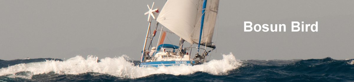
 But the course took us from 7 degrees South to 7 degrees North – straight across the equator and through a zone of variable winds In the end we faced light headwinds nearly all the way, which only eased to easterlies – allowing us to reach – on our final day. It was extremely hot but heading to windward meant a fair amount of splashing onto the foredeck – and closed hatches, making the interior of the boat a real hothouse.
More positively, we enjoyed an unusual amount of company. First a tired-looking Noddy, after much hesitation and flapping of wings, found a precarious perch one evening on the fin of our wind generator, and stayed with us all night, flying away again at dawn. Then, for two nights running, a very cheeky and bold adolescent Red-footed Booby decided to hitch a ride and sleep on our rear solar panel – leaving copious calling cards to remember him by; he was not in the least fazed by the flash of Nick’s camera. Nor was he deterred by our sounding a foghorn from only one metre in front of him.
For several days running a large school – maybe a hundred or so – of dolphins came and frolicked for hours on end, sweeping back and forth under the bows, leaping out of the waves, and generally showing off. We felt immensely privileged to witness this; it was hard not to believe that they were attempting some form of communication with us, or at least showing a kind of solidarity on our lonely voyage across the ocean.


A highlight, of course, was crossing the equator. This happened late one night and we made only partially successful attempts to record the moment on film: the photo shows the GPS reading, when we were already 0.017 of a minute North of the line (i.e. about 35 meters), sailing north at a speed of 3.4 knots.
 Fourteen days out, on January 19th, the high green hills of Ponape came into view, and the wind and current at last began to cooperate. By flying every inch of canvas that we have, we made 119 miles on our last day and reached the entrance pass just as dusk was coming on; kindly and at no charge, the Port Captain sent out a launch to guide us to a safe anchorage before darkness engulfed us. Next morning we motored the final couple of miles into the port and, among dozens of Chinese and Taiwanese fishing boats, checked into the Federated States of Micronesia.
 Ponape (also spelled Pohnpei) is one of four big islands – the others being Kosrae, Chuuk (formerly Truk) and Yap – that, along with their associated atolls, make up the FSM. These islands are also known as the Carolines and, until twenty years ago, were a Trust Territory of the USA; they still look very much more towards Guam and the USA than to Australia and NZ, and the shops are full of American products; the currency is the USD.
The history of Ponape is chequered but particularly interesting for the unique and massive ruined city of Nan Madol, that was the capital of the mysterious Saudeleur dynasty that ruled the island starting around 1100 AD. The city was built among tidal mangrove flats, in such a way that its “streets” flood at mid-tide; the most important edifices were constructed from basalt columns, laid lengthwise as one might if building an enormous log cabin. It is known that these columns were quarried at least 30km away; how and why they were transported to Nan Madol is one of those enduring Easter Island-like mysteries. We took a full day trip to the site and rented kayaks so as fully to explore this Venice of Micronesia; much of the vast complex is almost irretrievably overgrown and it was eerie as we paddled quietly down tunnel-like canals, with the tree branches meeting overhead and the weirdly geometric “logs” of the banks reminding us that this was all built by human labour.


In the small capital, Kolonia, you can meanwhile see what later rulers of the island left behind. A 100-meter stretch of wall is all that remains from the first European colonisers, Spain, starting in the 1880’s; the town’s main baseball diamond is called Spanish Wall and the adjacent supermarket (pun intended) is Wall Mart. The Spaniards didn’t stay long, selling Ponape to Germany in 1899. From the German era there remains a gutted church tower and two gloomy burial places: a mass grave of Micronesians from the Sokehs district who rose against their brutal overseers in 1910/11, and a cemetery that houses the remains of two German sailors killed while putting down the rebellion, as well as of a German governor.
 After WW1 Japan was awarded control of Ponape and the other Caroline Islands. Many Japanese settled here and the locals maintain a taste for Japanese cuisine. With war imminent again, Japan established a seaplane base and fortified the Kolonia area heavily; one afternoon we walked up to the top of Sokehs Ridge, that dominates the yacht anchorage, and explored the rusting old anti-aircraft installations. American forces bombed Kolonia heavily without actually attempting to take Ponape.
From 1945 to 1979 the US administered the Carolines as a single Trust Territory; that year a vote was held that resulted in Chuuk, Yap, Ponape and Kosrae holding together to form the FSM; the Marshalls, Palau and the Northern Marianas, meanwhile, each became their “own” country. But America continues to make massive investments in all of the island groups, under a succession of agreements known as Compacts, and the standard of living is much higher than you would otherwise expect in island groups with so few obvious means of income generation. FSMers have full and free access to the US (and vice versa), and many take advantage of this to enlist in the military and send home their wages; all about town you see bumper stickers such as “My son’s a Marine” or “Go Army”.
One result of free American access to the FSM is the existence of a large expat community, many involved in teaching (there is a quasi-university on a purpose built campus outside Kolonia), and a few living on yachts; there is also a fleet of derelict sailboats that, local lore has it, a businessman bought from disillusioned cruisers just because they “make the bay look nice”. A newer feature is Kathy and Noel’s venerable wooden ketch Integrity, which they bought in Nanaimo BC and which they are now refitting completely on a patch of land adjoining the airport causeway. As Kathy has obtained a three year visa to teach Chemistry and Philosophy (!) at the College of Micronesia, this will surely be a very thorough project…


Cruiser hangouts in foreign ports shift year by year, often according to the price of beer. A favourite in Ponape is Rusty’s, which is located in a post-apocalyptic ruined apartment building overlooking the harbour; here the island’s biggest band – “Wetter than Seattle”, a meteorologically correct reference to the climate – performs every couple of weeks. Closer to the dangerously dilapidated dinghy landing is the Oceanview Plaza, with wifi at USD $15 a month and all-you-can-drink iced tea, but Cupid’s, up the hill, has the cheapest happy hour.
The “real” locals meanwhile drink a form of kava called Sakau and the preferred cultural activity is cock-fighting, at which vast bets are laid every Sunday afternoon, after Church. Aside from the Japanese dishes, it has to be said that the local cuisine hasn’t too much to write home about, but there is one surely unique speciality: Ramen seasoned with Kool-Aid powder (preferably of the grape juice variety, Jim Jones’ favourite).
Early March and it was time to be off again. The 900-mile sail to the west-northwest and the USA’s island fortress of Guam was one of our favourites so far, once we had cleared the squally and wet weather south of 10 degrees south. With a warm wind over the quarter, never more than 20 knots and rarely less than 10, and moonlight nearly all the way, this was tradewind sailing how it was meant to be. We had a couple of our best day’s runs yet, up to 136 miles in 24 hours.
Several days out we heard of the terrible earthquake and tsunami in Japan, which resulted in warnings throughout Micronesia. As occurred in the case of the tsunami that hit Tonga and Samoa eighteen months ago, we must simply have sailed over the wave: a thirty-centimeter difference of height in one wave, when the average height is two or three meters anyway, is of course not noticeable. When we reached Guam we learned there had been a 90cm rise and fall in Apra Harbour, repeated several times, but the only damage was several submarines breaking their moorings.


A day short of Guam we passed over the deepest patch of ocean anywhere in the world: the Mariana trench, whose Challenger Deep bottoms out at nearly 10,000 meters, deeper than Everest is high. We commemorated the moment solemnly by paying tribute to Neptune in his lair: two Canadian quarters. We wondered how long they would take to reach bottom – and whether one day they would mystify some bathyscaphe driver ten kilometres down. And one night we had an unexpected hitch-hiker: a brown booby explored the deck thoroughly before settling down for the night on the starboard foredeck.
We were welcomed to Guam on March 16th, nine days out from Ponape. A B-52 flew overhead, outbound, and grey Navy launches shadowed us to make sure we did not stray into “non-approved” areas of the harbour. Nearby Tinian Island was where they loaded the bombs for Hiroshima and Nagasaki, while from Guam the bombardment of Vietnam, Laos and Cambodia was carried out; with the imminent arrival of an additional 10,000 Marines, ex-Okinawa, it’s sure that the military will be the dominant presence here for many years to come.
Guam was a pleasant surprise to us.
 We took a mooring off the Marianas Yacht Club, in a quiet corner of the large and well-protected Apra Harbour. Just across from us was Polaris Point, marked by a (presumably disabled…) missile and the entrance to the inner bay that is used by the US Navy. This was closed by a boom that would be pulled aside as and when warships needed to enter, and the approach was permanently patrolled.
The yacht club is an airy, open-sided building in a grove of pine trees. Although we were welcome to use it – including its delicious cold showers – at all times, it was active only twice a week: a “bar evening” on Fridays, and dinghy racing on Sundays. The caretaker was a veteran cruiser called Bob, who has lived on his boat here for the past twenty years; he even rode out Guam’s last Supertyphoon (a meteorological term, not just a journalistic exaggeration..) here, enduring winds of 160 knots and higher. In the rafters of the club are painted sign boards left by passing cruisers: we found boards painted by old friends Yawarra, who had been here no less than three times since the seventies, Ludus Amoris last met in the Strait of Magellan, and Sunstone, ahead of us in Japan’s Inland Sea. Before leaving we added our own roughly-painted sign to the gallery.
 The Club had the usual supply of old sailing magazines, which we read religiously from cover to cover, so as not to deplete our meagre stock of paperback reading. In one of the magazines, a year old, we were sad to read of the disappearance at sea of Kifu Chinami; Kifu was an eccentric but very amiable Japanese singleghander from Fukuoka whom we had first met in Tonga eighteen months earlier, and later in New Zealand; he had donated to us some Japanese charts and we had given him some advice on Chile, his next destination. His boat was last seen and heard of approaching Cape Horn from the west.
The only snag about the Marianas Yacht Club was its solitude and distance from anywhere, this in a land (unfortunately typical of the US) where public transport is almost non-existent. So we joined forces with American friends Phil and Mel of Mira to rent a paint-bare wreck of a Toyota for USD $25 a day For the first two days we endured a worrying whump-whump noise from the undercarriage, before we discovered that all four nuts on one of the wheels were about to come off; we also discovered the hard way that the car could not make it up any incline with the air-conditioning on, so as soon as we approached hills the approach was to open all the windows and turn the aircon off.
 Urban Guam was a massive culture shock. Tumon, sometimes described as the poor man’s Waikiki, is lined with Hermes and Gucci shops along with US chain-restaurants such as TGIF, Texas Steak House and so on; at the multiplex movie theatres we did not recognise the name of even one of the dozen or more movies showing, an indication of how out-of-touch you can become at sea. Out in the burbs at the Micronesia Mall we toured in wonder the aisles of a massive Payless supermarket, gaping at products we had long since forgotten; the only reminder of Guam’s remoteness was the advice given to us to shop for produce on Tuesday evenings or Wednesday mornings, just after the ship from San Francisco had unloaded. At a vast Home Depot – reputedly the biggest in all the US – it was a true pleasure to pay only $4 for a can of WD40 that in the islands would have cost us $20 or more, and at K-Mart we bought clothes in anticipation of the colder climate in Japan.
We caught up on all our electronic correspondence at the United Seamen’s Service, a kind of Seamen’s Mission, close to the yacht club; this operated a bar, restaurant, and free internet. We also caught up on the news. The devastating earthquake, tsunami and their consequences were of course the headline news on CNN. With Japan as our next destination this was of course of some concern. But of even greater concern – this perhaps not understood nor appreciated by non-sailing friends – was the prospect of facing a typhoon, which was very real should we linger too long in Guam. Bob’s experiences notwithstanding, this was not a risk we were prepared to take. There is a “typhoon refuge” in Guam – a narrow creek with concrete moorings laid – but when we inspected it, we found it already half full with derelict and untended yachts and Bob told us the moorings had not been checked for years. We needed to be gone, we decided, by mid-April at the latest.
Unlike the rest of the Marianas, Guam was a US Territory (ceded by Spain) before WW2. Virtually undefended, it was seized by Japan the day after Pearl Harbour. The occupation was brutal and is remembered with bitterness by the native Chamorro population. Following massive aerial bombardment, US Marines launched an amphibious assault on July 17th 1944, landing either side of Apra harbour, at Asan and Agat. In a pattern that was to become familiar as US forces progressed painfully north towards the Japanese mainland, the invasion was fiercely resisted by troops well-concealed in excavated cave systems and prepared to launch so-called “banzai” attacks (suicide attacks) as a a last resort. In various locations, including behind the yacht anchorage at Piti, massive defensive guns can be found almost overgrown in the dense jungle.


There are discreet monuments to the war in many places. Asan beach, where 2500 Marines died, is now a grassy park where children fly kites and people picnic on the weekends. The Japanese flag flies alongside the Stars and Stripes and most of the tourists are in fact Japanese. Strangely, and in contrast to Normandy, there are no US war cemeteries here (or at any of the war sites, including Guadalcanal, that we have visited): all of the bodies were repatriated. It’s odd too that there is no officially-sanctioned museum on Guam: the very few colonial buildings that survived the bombing are falling down, and the only collection of war relics, which includes the tail section of a Japanese “Betty” bomber, is a private one.
It is perhaps understandable that for most Europeans, and Canadians even, the War in the Pacific seemed to be something of a sideshow. For Americans it is less understandable. For the enemy in the Pacific was just as redoubtable as in Europe, the logistical challenges greater and here it was a question not just of one massive – if very high-risk – landing operation, but of a whole string of such landings, each one of which was fiercely opposed and which only took the US a little closer to the real objective: the four main islands of Japan. We were humbled by visiting these battlefields. The Kiwi skipper of the only other visiting yacht confessed, too, that he had grown up as rather cynical about America, but what he had seen as he came north from one battle-scarred island to another, had made him a convert: “we’d be speaking Japanese now, if it weren’t for the Yanks”, he said.
Of course, there is older history as well. A ‘must” on our list of sights to see was Umatac Bay, an the southwestern corner of the island. On March 6th 1521 Ferdinand Magellan made his first landing since leaving the stormy waters of the Strait that now bears his name, some 7000 miles behind him. The experience was not a happy one; he named the islands the “Ladrones” (Thieves”), an appellation that stuck until relatively recently, and moved on hastily.


Umatac today is a quiet village, with a bar called “Magellan’s Landing”, its sign sponsored by Budweiser, and a white concrete column marking the presumed landing site. The bay is surprisingly small and would only take one or at most two modern yachts; Magellan must in fact have anchored his unwieldy Trinidad well offshore, and landed here in his small boats here. Overlooking Umatac is a small fort of a slightly later period. Also from the later Spanish occupation (which lasted until 1898) are the remnants of an old coast road, including beautifully constructed stone bridges.
 Much of the north of Guam is occupied by Andersen Air Force Base, but there is good hiking on the southern coast and in the interior. We made several walks to island peaks, waterfalls and to the beaches. In this remote hinterland a Japanese private soldier, Shoichi Yokoi, hid out for 28 years after the end of WW2; he was finally captured close to a tacky resort restaurant called Jeff”s Pirate Cove; his picture and story now adorn Jeff’s plasticised hamburger menu.
In between shopping and tourism bouts we were, as is usual, scrutinising the weather outlook. It was late March and early for any typhoon activity but some persistent lows were these days hanging around in the islands of Yap and Palau to the southwest. The risk was growing that one of these would “go cyclonic” and then start moving west towards the Philippines; then, typically, it would either continue due west or re-curve to the northeast, towards Guam and/or the gap between Guam and Japan. Although the weather charts indicated that two or three days out we would have to cross a “shear line” – a kind of front, with increased winds and rain – we decided it was better to get moving than linger in Guam to see what that pesky low intended doing. After a final shopping orgy and a phone call to the meteorological office, we checked out on Monday March 28th and by 15:15 were outside the breakwater and hoisting our sails, the course 320 degrees, destination Japan.
More: Japan – Kyushu