 In late May 2016 we paid a one-week visit to Bosun Bird in Cordova (Alaska), again taking the Condor Airlines charter from Frankfurt to Anchorage. The primary objective was to move the engine from its tight cubby-hole under the cockpit, and into the main cabin, where – hopefully – Jerry, Cordova’s all-purpose mechanic, could get at the transmission and resolve a persistent oil leak.
Moving an engine is easier said than done: a host of wires and hoses need to be disconnected and labelled, hoisting beams arranged in the companionway, and a sturdy set of supports set up in the main cabin. However, all went according to plan, and we decided to take advantage of the engine being out to replace the cutlass bearing (the rubber-lined tube through which the propeller shaft exits the boat).
We were blessed with a week of beautiful crisp spring days in Alaska, with almost no clouds to be seen, the snow still low on the encircling mountains, almost no wind. Rather than attempt to live on board (complicated with an engine to be climbed over, and the nearest toilet half a mile away), we stayed in a B & B, the Dragonfly Inn; but we treated ourselves to one or two meals out, including at the fishermen’s favourite breakfast spot, the Coho Café (a sign in the bar: “If assholes could fly, this would be an airport”.).


We flew back to Juba and left Jerry to it. Back in in Juba (South Sudan) the security situation was rapidly deteriorating and we now found ourselves in a race to tie up all our leaving arrangements before everything fell apart, perhaps in a repeat of the dramatic fighting of December 2013. As it turned out, we got out again, on July 1, just a few days in advance of a firefight that left nearly three hundred dead in the capital, and my unfortunate successors seeking refuge in the USA Embassy.
Prince William Sound to Southeast Alaska
 Back definitively in Cordova, this time via Seattle and the Alaska Airlines milk-run that flies North up the coast, we found Jerry had been largely successful, replacing two critical seals on the transmission and successfully extracting the old but stubborn cutlass bearing. Everything was patiently reassembled but we were not completely surprised when, as we tentatively turned the ignition key on, an old problem re-emerged: insufficient oil pressure. This was a familiar problem, which fortunately we knew how to fix; partial disassembly of the engine again, and cleaning of the pressure relief valve. While this was going on, across the world my former colleagues were dealing with issues of a different kind: a re-run of our 2013 evacuation of the Canadian embassy was now being contemplated.
Also back in Cordova by now were our Quebec friends, Guy and Claire, whose steel Balthazar had endured the winter placidly parked on land next to Bosun Bird, having traversed the Northwest Passage. We spent an evening on board with them, exchanging plans for the upcoming summer, and mutually congratulating each other that our vessels had survived the winter: the most alarming moment, we had now learned from Jerry, was not one of those hurricane force williwaws that blast through Cordova in the Alaskan winter and that had sent a yacht flying the previous year, but a major earthquake: this had shaken Balthazar’s supports and left her able to rock a little, but Bosun Bird had held firm. Another evening was spent with Colin and Marion, who had just arrived on their NZ-registered Avant Garde after spending the Spring cruising in Prince William Sound and who were headed the same way; their guests Don and Marilyn owned a boat in Opua (NZ) and recalled seeing us tied up there several years ago; as always we found we had many mutual acquaintances, and Colin and Marion were very keen to share with us their enthusiasm for Japan.
Launch day always means some trepidation, but Glen, the Travelift operator, placed us in the water tenderly, there were no obvious immediate leaks and the engine started. After a couple more days of the crew compulsively clearing most of the shelves of Cordova’s supermarket and indulging in the internet, we motored out to spend a quiet afternoon and evening getting the boat in order at Deep Bay, just three or four miles out of Cordova. This is a favourite hangout for sea otters: at any one time we could see twenty or thirty, and as the evening drew on and then later went mirror-still, we could hear them huffing and puffing as they came ever closer, sculling lazily around on their backs.

 It looked as though fine westerly weather would hold for several days, in other words we had a window for the 350-mile run across the open water of the Gulf of Alaska to the first opening into the maze of islands and channels that should then allow us protected sailing most of the way down to British Columbia: the panhandle-like appendage of Alaska known as Southeast. But first we needed to head thirty or so miles in the opposite direction, so as to exit Prince William through the wide and navigable entrance called Hinchinbrook; there is a narrow, shifting channel from Cordova straight to the ocean, that saves a lot, but its reputation is a fearsome one and we were not tempted by the reassuring suggestion of local fishermen to “Just follow us: you can’t go wrong.”.
In thin fog and over glassy seas, we motored for two or three hours, but a light Northwesterly then came up and allowed us to sail the rest of the 25 miles or so to Double Bay, just inside Hinchinbrook Entrance; Avant Garde joined us here late in the afternoon. Next day, with the forecast now looking good for four days but no more, we decided to leave early and head right out into the Gulf, rather than take a more leisurely, short day, to one more anchorage within the Sound. We had a long beat into westerlies that had become southerlies in Hinchinbrook, but by early afternoon we were clear, and reaching at five knots almost due East.  As dusk came down, around 22:00 we could just make out, thirty miles ahead, the rugged cliff of Cape St Elias, which is at the tip of an island (Kayak Island) that bizarrely juts out, almost at right angles for 20 miles or so from the otherwise smooth sweep of the Northeastern Gulf of Alaska. On May 11 1778 Captain James Cook spent several days in this neighbourhood, and at the foot of the Cape he left a bottle with two silver pennies, and an inscription; these have never been located; the name “Kayak” is probably a corruption of the original name given by Cook, which was “Kaye”, after a certain “Reverend” held in high esteem by Cook.
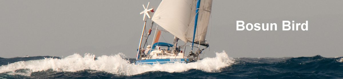
The wind gradually shifted from Southwest to West, and we adjusted our sail plan to Bosun Bird’s favoured format for running: the mainsail reefed well down and held out by a preventer, with a staysail poled out on the opposite side. This makes for a very rolly gait but we kept moving in the right direction as the wind rose and fell between 10 and 25 knots.  Our Aries wind vane, which had not seen sustained use for several years, was called into action and performed as expected, needing only the occasional tweak as the wind shifted a few points one way or the other.
After the first day, a grey overcast took over and, with Cape St Elias behind us, we could no longer see the coast to port.  Three or four ships a day overtook us: several large white cruise ships plying between Glacier Bay and Prince William at 17 or 20 knots, and fishing boats and tugs at a more sedate seven knots. By dawn of the third full night out, we were closing the coast again, and as the morning advanced the cloud gradually lifted.
The spectacle to port was magnificent: the huge La Perouse Glacier sweeping directly into the blue ocean, across a dazzling two-mile front, with snow-capped mountains rising directly to 3000m and 4000m behind. A pair of Blackfooted albatrosses soared and swooped in our wake, several times we saw the distinctive and menacing fins of Orcas (Killer Whales) and at one point we were distracted by a heavy thumping sound: a humpback whale was rhythmically beating the surface of the sea with his huge tail, every five seconds or so, in a large circle. It seemed to us that we were a very long way from the man-inflicted horrors of South Sudan.
 By mid-afternoon the wind had almost died and it looked as though we would not clear Cape Spencer, the entrance to “Southeast” and the Inside Passage, So after careful consultation of the chart, we steered for a deep inlet identified as Port Graves, barely three or four miles North of the Cape. These inlets are open to the prevailing heavy swell from the west, and we were impressed to think of La Perouse scouting his way through these waters in his clumsy Astrolabe;
  he was not in a position to maneuver into the small nooks, off the main inlets, that take you out of the swell and into flat waters.
After the anchor had rattled out in Murphy’s Cove, we glanced over to the beach at the head of the bay: it was low water and a Grizzly was idly mooching for clams; he eyed us silently for a few moments, then carried on.
We spent the next day exploring, and gathering berries: we were a little late for salmon berries but early for blueberries, and you could see where bears had beaten us to the prime bushes, but there was plenty for that night’s dessert. There were Grizzly prints in the wet mud below the high tide mark and near-steaming “visiting cards” higher up.
By now we were back in VHF range. The forecast for the next day called for calm in the morning, but picking up to 25 knots of inflow wind, into Cross Sound (past Cape Spencer) in the afternoon. So we made an early start. It was dense fog all the way in, the kind of conditions that – prior to GPS – we would not have contemplated taking on in the past. Although the winds were utterly calm, it was eerie motoring through mile-wide tidal swirls and sudden patches of white water off the Cape:  this would not be a good place to be in heavy weather and with a strong tide running. And GPS doesn’t help you detect other ships: visibility was at most 50 meters and we had to make a white-knuckle swerve when at one point the 100-ton Pavlov loomed up directly ahead of us, pushing its white bow wave towards us at seven knots.
 We nosed our way carefully into Elfin Cove, the first safe location inside Cross Sound. This is a snug little place, a base in summer for thirty or forty fishermen, but whose permanent (winter) population is only 7. There are a couple of ultra-expensive fishing lodges (USD $1000 per day) and a lot of more rustic log homes built the length of a boardwalk. We tied up at the 400ft-long transient wharf in the outer bay, but an inner bay – reached via a very narrow tidal channel – would give safe haven even in the worst Alaska storms.
There is one small but surprisingly well-stocked store, where we did some restocking, a very large book swap, and a laundromat with showers – all of which we took advantage of. The transient wharf was busy: one evening we had round to visit the three young French girls aboard Jolo, a steel yacht that had come this way from Singapore via the Philippines and Japan, and the next afternoon it was drinks aboard the large powerboat astern of us, Western from Victora, BC; Ken, the skipper of Western, was retired Royal Canadian Navy, and had spent a period as skipper of HMCS Oriole, the Navy sail-training ship on which we had once cruised; he had many tips about the waters ahead of us.
Southeast Alaska
 Nothing but rain and fog was now forecast. So we decided not even to attempt to secure one of those elusive permits to enter Glacier Bay: we would likely see very little, and in any case you needed to remain in cell-phone range for days on end in the hope of getting a permit. Instead we headed out next morning in the mist for a short run across the fast-running waters of South Inian pass, to Inian Cove. Misty days like this can be very beautiful: fir-clad islands appear and disappear eerily, ridges emerge above unseen shorelines, the water is a greenish-turquoise colour, and the sea lions breathe hoarsely, their breath fogging in the damp air.
 On the beach at Inian, we burned ten days’ worth of rubbish, taking the crushed but now clean tins and the few surviving scraps of tin foil back on board. Then another long walk on the beach, and over a saddle to a bay on the other side of the island. There were no berries to be had, but the fact that Mr Bear had been here very recently was very much in evidence; the crew has bought a bear-bell for walks such as this, but invariably forgets to bring it along and spends most of the walks bleating “Ahoy, bear!” in the hope of deterring Grizzlies.
From Inian we headed across North Inian Pass – more powerful eddies, even at slack – and into the only-recently-charted waters of Dundas Bay, a long dogleg that reaches right into the mountains West of Glacier Bay proper. There were no boats to be seen, just the forest coming to the water’s edge, the mist sweeping in and out, sea otters lolling and eyeing us curiously, unseen ravens calling “Bronk! Bronk!” as we passed. It rained all that afternoon, and next day blew hard as well, but we were safely tucked up.


By now it was evident that this year’s summer in Alaska was going to be a lot wetter than last year’s: for every day for a week and for every forecasting zone in Southeast Alaska, the outlook was ““Rain” (not even Rain Probable, or Periods of Rain). But in intervening periods of drizzle we ventured ashore to explore the beaches at low tide; one day we saw a pair of moose working their way around the mudflats at the head of the bay.
We felt our way back in fog to Inian, then had a 04:00 a.m. rise one morning to head East into Icy Strait (so named on account of the icebergs that find their way here from Glacier Bay), and further into the maze of channels that make up this northernmost stretch of the Inside Passage. Everywhere, you must take current predictions into account, or waste hours sailing at four knots against a three knot current. For most of the morning we had blustery sailing, with a rainbow astern but, as we neared Point Adolphus it was time for the tide to change, and it seemed to take an awfully long time to pass this landmark.  The Humpback whales seem to like to follow the tide line, and there were puffs of whale breaths all around us; when the wind died you could hear their old man’s exhalations, followed by a sudden intake of breath. Five or six such breaths, then the whale would show a bit more fin than usual, his great tail would emerge and – the water falling from it in a curtain – he would sound for three or four minutes. Mega cruise ships, some with 3000 passengers on board, would emerge from the fog then disappear again: Juneau-bound, or simply killing time as they awaited their time slot for entering Glacier Bay.
We spent a night at Flynn Cove, on the South shore of Icy Strait: for once the detailed American charts were wrong, showing a 60m-long island, with a hundred or more healthy spruce growing on it, as a ‘submerging reef”, but generally they were surprisingly dependable. As in so many remote locations where we have sailed, it was breath-taking to think of the challenges faced by the early European navigators – in the case of Icy Strait, Captain George Vancouver in 1794 – as they felt their way through these fog and reef infested waters, with no sense of where any of the myriad channels, with their baffling winds, might lead; but so accurate were the charts they drew up that in the 1950s a Canadian Navy vessel successfully negotiated the entire Inside Passage using only the charts developed by Vancouver on the Discovery and the Chatham.
 Ten miles further on, and were off the small Tlingit village of Hoonah, population around 700. Hoonah was once the location of a major salmon cannery, but was hit by the advent of refrigerated fishboat tenders and the closure of 90% of the canneries; Hoonah has had more success than most of the settlements in these remote waters in reinventing itself. The cannery has been refurbished as a museum cum-mega gift-shop, cables have been strung up to a nearby mountaintop to form the world’s longest zipline, and everyone with a launch and a small outboard now offers whale-watching tours (with money-back guarantees); those cruise ships idling to enter Glacier Bay have been successfully tempted in – two or three a week now call, and the entire town changes gear to deal with the massive, short-lived influxes of tourists. Among the many interesting gifts on sale at the old cannery were Scotch tape dispensers in the form of sea otters: if only I still had an office, where one of these could have been given pride of place…
 But there is still a small, active fishing harbour, and here we tied up for a couple of days to re-stock at the Hoonah general store, and take advantage of the hot showers and book swap at the harbourmaster’s office. There was even wi-fi at the rambling, run-down pub called the Icy Strait Lodge, a fifteen minute walk out of town
Leaving Hoonah at 07:00, we ghosted our way out, under genoa, past the massive Sun Princess, tied up at the cannery; there was a lone tourist who waved at us from seven decks up; everyone else, we deduced, was probably enjoying bacon and eggs at the all-you-can-eat free breakfast buffet. Eighteen miles, today, to Whitestone Harbour, at the Northern entrance to Chatham strait, which, three to six miles wide, and eighty miles or so in length, is one of the great North-South thoroughfares of the Inside Passage.  We explored ashore, found some remnants of logging operations from fifty or a hundred years ago (many of the mountainsides hereabouts show the evidence of ruthless clear-cutting) and harvested a few berries: it was our sense that summer had perhaps come earlier than usual this year; the berries were nearly all gone, and it was only early August.
Another early morning (05:20) to take advantage of the tides, and by mid-morning were already tied up at Pavlov Harbour, 22 miles on; as the name indicates, we were now travelling into areas whose early exploration was conducted more by Russians than the English. This was a beautiful, apparently wild location, but we were a bit perplexed when, first, two of the largest private power yachts we had yet seen (VODOWS – Vulgar and Ostentatious Displays of Wealth) pulled in, and then a succession of small floatplanes buzzed in and deposited small groups of people on the rocky beach, as low tide approached. All became clear as low water approached. Up the creek at the head of the bay was a fine waterfall, and in front of it some twenty or thirty people gathered. At about 19:00 the first great Alaska Grizzly appeared from the trees on one side; within a few minutes he had been joined by an extended family, including two generations of cubs. For an hour or more the seven bears wandered in and out of the shallows and along the top of the waterfall, batting at the salmon that were flapping around in the shallows, or bravely attempting to scale an adjoining artificial fish ladder. Twice we saw one of the larger bears catch a fish in its paws, then hold it down until the cubs could splash their way over and finish the job.


As dusk fell, three floatplanes in succession cruised in, picked up their loads, and sailed upwards into the darkening sky; we were left alone again, with just the throb of the VODOWS’ generators.
Next day was thirty miles due South, down straight-as-an-arrow Chatham Strait. We anchored off the village of Angoon, another small Tlingit settlement on the Strait’s Eastern shore. The Lonely Planet guidebook acknowledges that this is a great place to start a kayaking expedition, but hints that outside visitors are not as welcome as they might be. This may be on account of Angoon’s history: the village was destroyed in 1882 by a US Navy gunboat, as revenge for a Tlingit uprising against a local whaling company; compensation took nearly a hundred years to arrive; in 1973 the federal government made an out-of-court settlement for a rather paltry USD $90,000. Anchored off Angoon, we had a rare (relatively) clear evening and could make out the dramatic snow-capped peaks to the west that back Sitka.
 We had a brisk reach across the strait next day and entered another strait leading off it, to the West, at right angles; Peril Strait. Not necessarily as challenging as the name might indicate: this is an only approximate translation from a Russian word better rendered as Pernicious, which is/was a reference to the 200 or so Aleut fishermen, working for the Russians, who died here in a nineteenth-century case of shellfish poisoning; other local reminders of the episode are Deadman Reach and Poison Cove. . We inched our way in to a very picturesque but rather constricted cove at Point Moses, on the South shore. In the afternoon, with the sun now having made a rare appearance, we ventured inland, into dense bush, in search of a lake called Eva, supposedly just a mile inland. Bushwhacking in Southeast is very hard going indeed: rotting, fallen trees have to be climbed over or under, there are many varieties of spiky vegetation, the vegetation is so dense that you quickly lose all sense of direction and, if the crew has again forgotten her brand new bear bell, you are obliged to make a lot of noise the whole time. After two hours we had only located a small swamp. We attempted a shortcut back, which took three hours. By the time we were back on Bosun Bird, the crew was no longer talking about the special dinner she was planning on account of our having negotiated Chatham Strait; in fact she was not talking at all, and went straight to bed.
 Next day was pleasant upwind tacking, in sunshine across three-mile-wide Peril Strait: more whales, and the Alaska ferry Le Conte passed us. Appleton Cove was more spacious than Moses: Canada Geese honked from the extensive shallows at one end of the bay and, ashore, we found an old logging road that headed up into the hills and allowed us some strenuous leg exercise. This time the crew remembered her bell: we saw lots and lots of Bear visiting cards, much of it quite fresh (steaming, in fact…) but the bell seemed to do its trick. And although the salmonberries this year were disappointing, here we found some new red berries that, after a cautious tasting, were delicious (and apparently non-noxious). From Appleton, we headed via Nismeni Cove into the dead-end of Hoonah Sound, but our spirit of adventure was rewarded only by two days of pouring rain and mist, so we cannot report that we saw much of Hoonah Sound.
 Now Peril Strait turned suddenly South and became a lot more constricted. We played the tides carefully as the strength of the current increased with each passing mile. In one particularly tortuous stretch – Adams Passage – we were somewhat concerned to figure out (this from a reading of our AIS) that our transit would coincide with that (in the other direction) of the Alaska ferry system’s largest vessel, the Columbia, the size of a medium cruise ship. All went well – we spoke with bridge by radio and asked them to look out for us – but there was an unnerving moment when we had the ferry coming straight for us at 20 knots, before veering away into the bend, maybe 50m in front of us. Anchorage that night was in a tranquil lagoon reached after some intricate reef-dodging, called Baby Bear; alas no bears in sight.
 Next was one of the milestones of this cruise: the passage of Sergius Narrows. This is the only way to Sitka (barring approach from the open North Pacific), and the Narrows can be rather busy as well as being excessively narrow (maybe 50m) and running at up to eight knots. We let a tug with a massive barge precede us, and allowed three fishing boats to emerge before we ventured in, at slack water and on a misty, drizzly afternoon: all went well, but this would have been no place to coincide with the Columbia.
 The rain and mist were now all pervasive, and the forecast seemed to give no respite: “Winds Southeasterly: Rain”. But in an attempt to pre-empt cabin fever we still ventured out most days in our waterproofs, to explore the beaches and gather blueberries. We were now nearing Sitka, formerly New Archangel and the capital of Russian Alaska. More and more of the islands and bays had Russian names and/or translations of those names: so, after a couple of days anchored in St John Baptist Bay, we entered Neva Strait, which is named simultaneously for the Neva River that runs through St Petersburg, and for a Russian sailing ship that served New Archangel in the 19th Century. The crew had to be corrected when, quizzed as to the name of the peninsula along which we were sailing, she studied the chart and responded “It seems to be a part of Shikova Island”; in fact it was Partofshikova (all one word…).
 From the Magoun islands, where we spent several quiet days exploring on beaches criss-crossed with bear tracks and where every tree seemed to harbour a bald eagle, we could make out the Mt-Fuji-like cone of Mt Edgecumbe, usually snow-covered and which serves as a sentinel for Sitka, and which was the landfall for Russian sailors who had crossed 5000 miles of the North Pacific, from Petropavlovsk on the Kamchatka peninsula. And as we neared Sitka itself, the skies cleared for what seemed like the first time in weeks, and we could make out the jagged peaks behind the town.
 Soon we were tied up in Sitka’s main fishing harbour, which we plan to make our base for much of the winter.
A leaflet given to us by the harbourmaster refers to two principal hazards here: there has been a lamentably high incidence of inebriated crew of fishing boats falling into the frigid harbour waters on late weekend nights (and promptly drowning); mariners are advised to “use the buddy system when walking back to their vessels at nights”.  Then there is some carefully worded discussion of what is called “the sealion issue”; sealions, which can be very large and quite aggressive, periodically haul out on the fishing harbour floats; but while this is recognised as “inconvenient”, users of the harbour are formally warned that it is an offence physically to dissuade them from this, and it is not permitted to direct high-pressure hoses at them either.
More: South to Kerguelen