For supplementary details, including GPS coordinates, see Kodiak and Alaska Peninsula for Cruisers.
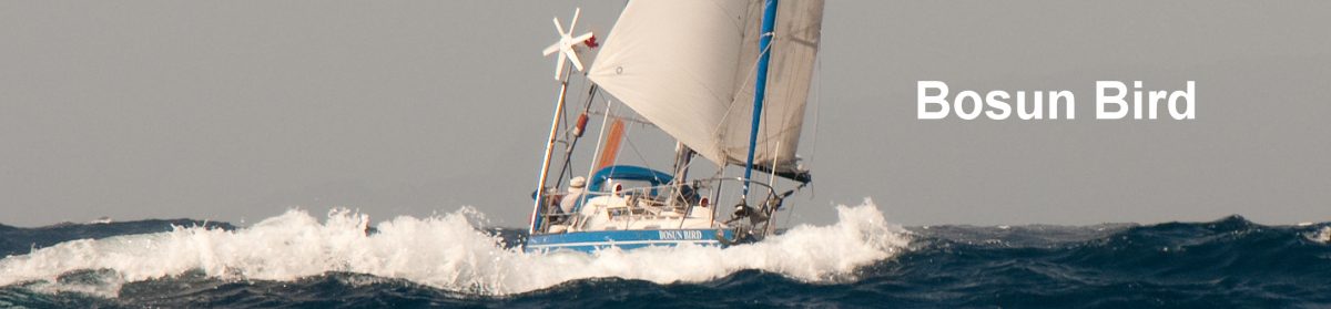
We arrived back in Kodiak,via London, Ottawa, Vancouver and Anchorage in late June 2014 and immediately set to restoring Bosun Bird – who had patiently waited two years for us on the hard at Fuller’s Boatyard, in company with a large number of local fishing boats – to seaworthiness.
- Fitting Out and Shakedown Cruise
- Alaska Peninsula
- Afognak Island
- Southwest Kodiak Island
- Aleutians in Comfort
Fitting Out and Shakedown Cruise
 In June in Kodiak it is light until midnight, and dawn comes round 03:00 a.m. But the weather is always changeable: there were days of blazing sunshine – T-shirt weather – but these could be followed by two or three days of driving rain and cold.
 For the first few days we stayed in the local motel, the Shelikof Lodge, and we made use of a U-Haul rental to ferry sails and other boat material that we had left in dry, heated storage; to our delight, our four heavy batteries – bought in Japan – were still entirely serviceable, and also to our pleasure the engine re-started at almost the first attempt. We frequented the newly-relocated public library for free internet use and to catch up on the news (mainly the World Cup finals in Brazil), and the equally fine public swimming pool for hot showers; there were also several visits to our favourite restaurant, the Japanese-themed Old Power House.
We reacquainted ourselves with the unique local ambiance (as featured in the hit reality show, The Deadliest Catch). Kodiak is very much a working port, one of the busiest fishing ports in the USA. Life on the salmon fishing boats can be very lucrative but it is hard, and it attracts many colourful characters. One of our neighbours complained ruefully one morning that he had just had to fire one of his crew for drinking an entire bottle of vodka and breaking windows on the boat; the public washrooms at the yacht harbour are the favoured hangout for unemployed or wannabe crew, and on cold days they jam the hand-dryer on to heat the place; many of the Latino cannery workers, who live in hostels, spend their few off-hours lingering over a single coffee at McDonalds and making cellphone calls back to their wives and girlfriends back in Nayarit or Sinaloa.
 After five or six days working on the boat, we were ready to go back into the water; Bill, the yard manager and Travelift driver, carefully manoevered us into the narrow channel on which the boatyard lies and bade us happy sailing.
Back in St Paul Harbour we made friends with local sailor Tom of Seamoor, who gave us many hints of possible anchorages in the neighbourhood; and Marty, the just-retired harbour-master, kindly invited us round to his waterfront home for another evening of chart perusal. One morning in came a beautiful, very distinctive yacht called Sunstone, whom we had first encountered at Mar del Plata (Argentina) nearly a decade ago, and last met in New Zealand four years ago; we renewed our acquaintance with Tom and Vicky, and they gave us even more ideas for anchorages; they will go on this winter to our home cruising areas in British Columbia.
 Usually after a long spell of the boat being out of the water and her crew inactive, something goes wrong first-time out so we always like to make our first run a short one. On local recommendation, we sailed out one sunny morning for Long Island, only five or six miles away in Chiniak Bay. Seven or eight kilometers in length, the island has a large lagoon at its Southwest end that makes for very secure anchorage. But you are immediately back in wild Alaska: Humpback whales blow just off the harbour entrance, bald eagles nest in the spruce forest, seals swim around the lagoon. On shore we followed old tracks through the forest, past collapsed and moss-covered Nissen huts to massive gun emplacements and concrete bunkers at the tip of the island. These date from WW2; at one time there were 5000 troops stationed on Long Island, in defence of Kodiak in case of a Japanese seaborne attack (Dutch Harbour, in the Aleutians, was indeed bombarded, but Kodiak was apparently always under cloud…). The cliffs where the guns sit were capped with bright purple lupins, and Tufted Puffins came and went; far below we could see Sea Otters lounging around on their backs in the kelp beds.
Alaska Peninsula

We were welcomed into the small fishing harbour (which does not appear on charts) by John, the part-time harbour-master and, like most of Ouzinkie’s natives (pop 160), an Alutiiq (not to be confused with the related Aleuts). John had tried the city life in Anchorage, but said he couldn’t abide having to go around with his infant child on his chest and a gun at his waist, so he was back in Ouzinkie to stay.  We also chatted with one of the local gill netters: the salmon seemed to be running a little late this year; like all the fishermen, he spends much of his time calculating the differential between the price of fish delivered to mother ships or to the cannery in Kodiak, and the price of diesel; in poor years the smaller boats, which consume less fuel and have smaller fish quotas, do relatively better.
 Ouzinkie has a tiny, beautifully kept Russian Orthodox church and cemetery, just behind the harbour; John claimed (only half seriously…) that when William Seward bought Alaska from Russia for USD $7.2m in 1867, Russia reserved the right to reoccupy Ouzinkie, There is a US Postal Office, a City Hall and an airstrip with a daily service to Kodiak.
We timed our next passage westwards for the tide in Ouzinkie Narrows, and spent much of a day beating into a fresh westerly breeze until we were off the maze of channels and islands that all but blocks the entrance to a deep fjord called Anton Larsen Bay (not to be confused with Larsen Bay, elsewhere on Kodiak). Using notes gleaned from our contacts, we worked our way in carefully through the center of three available channels and found anchorage in a lake-like lagoon; large patches of snow remained on the slopes of the mountains all around. One day we took a long walk through the forest to nearby Sharatin Bay, collecting en route salmon berries that were just starting to come into season; as these berries are also much appreciated by bears, a wary eye is necessary around berry patches.
Working west, it was necessary to time our approach to the half-mile wide Whale Passage for slack water; at other times currents reach up to seven knots, and conditions can become dangerous when the current is opposed by wind. Exiting the pass, we found ourselves in a wide, steep sided fjord called Kupreanof Strait, angled to the northwest into Shelikof Strait. We found anchorage behind Dry Spruce Island, with, across, the bay, the buildings of the abandoned cannery of Port Bailey clearly visible. Next morning we were up at 04:30 to catch the first of daylight and the last of the tide to Shelikof.
 In the Shelikof, it seems that the winds always blow hard, and always up or down the Strait (i.e. from the NE or the SW); there does not seem to be much in between. Northerly winds bring rain and cloud, Westerlies clear skies but can be a lot stronger, commonly reaching 40 knots or more on the Peninsula side. Fortunately, we had a 20 knot Northeasterly, on the beam, for the entire 32-mile crossing, with snowcapped peaks occasionally peeping tantalisingly through the clouds to the west.
The mountains on the Peninsula side of Shelikof are much higher than on Kodiak: here they reach around 2500m; they are perpetually covered in snow, but what at first sight appear to be large patches of dirty snow on many mountainsides are in fact huge areas of volcanic ash, left over from the massive 1912 eruption of Mount Katmai (the second largest recorded eruption in history, after Santorini).
After a 53-mile day we wound our way though narrow channels to the emerald green and still waters of Amalik Bay; from a drying strand to starboard a Grizzly Bear eyed us motoring in, then resumed his search for mussels. The tides on the Peninsula have a range of up to 8m, so it is not always easy to find snug anchorage with appropriate swinging room. Amalik was safe enough but as the wind picked up in the Shelikof, it bounced off the mountains that surround the bay, creating fierce williwaws of unpredictable direction, so after a couple of days we moved deeper into the mountains to a small complex of lagoons known as Geographic Harbour (after the National Geographic reporter who came here to report on the Katmai eruption).
Geographic happens to be Grizzly City. Over the several days we spent here there was as often as not a Grizzly Bear in sight on the tideline or lumbering up into the salmon berry patches. Several times we saw the same sow with her new-born cub, sniffing among the rocks about 30m away from Bosun Bird; another time we saw a young male suddenly take fright when a patriarch appeared a kilometer or so away at the other end of the bay. Big males, with their distinctive hump, would eye us quietly for a minute or so, but other than that take no notice of us; one swam by us, blithely, only 20m or so off our bows. They aren’t always so peaceable, of course. Only a little way up the coast was the old haunt of TV nature personality Timothy Treadwell, who spent 13 summers getting to know the brown and black bears of Katmai; he evidently became overconfident; in 2003 he and his girlfriend were attacked and killed by a Grizzly here (as featured in Werner Herzog’s movie Grizzly Man).


Next we headed a couple of miles further up the Peninsula and took an opening that led almost due North into the mountains. At its head, ten miles in, was a narrow entrance between cliffs, with a navigable channel only 20m wide, and strong currents coming in and out at all except slack water, Inside was the perfect natural refuge of Hidden Harbour where we spent more peaceful days bear watching, rowing around the lagoon, exploring the rocks at low tide; nowhere we have been have we found beaches so pristine and so devoid of any sign of human existence.
 There is always a price to pay. At Hidden Harbour, we discovered that our alternator was failing to charge the batteries, as required; various tests conducted by the crew determined that it was moribund. We have a spare so this was not the end of the world, but the spare is an imperfect fit and it is impossible to align as perfectly as you might hope; this meant that we would need to schedule a return to Kodiak, to fix the original part, sooner than we had hoped.
 Meanwhile, with the winds predicted to move to the SW we ventured out one more time into the Shelikof for a further run up the outside of the Peninsula, some 20 miles to Kukak Bay. It was a bright and sunny day, there were a few fishing boats about, and we raced wing-on-wing up the coast at six knots with massive volcanic snow-capped peaks rearing up to port. A couple of times there were puffs of steam among the whitecaps all around, and once the huge tail of a sounding Humpback lingered in the air a few seconds, only thirty meters away; Sea Otters lay on their backs in the wave troughs, contemplating starfish or other tasty morsels on their chests and – failing to hear us approach – would only sense us when we were a few meters away, at which point they would give us a look of horror before diving.
 At Kukak we found another calm anchorage off the rusting, nearly overgrown ruins of an old cannery, with small islands all around. We explored by dinghy and on foot. There were Grizzlies far in the distance, and fresh tracks on the beaches. For an hour a pair of inquisitive river otters – smaller and sleeker than their seagoing counterparts – followed us before getting bored and going to find a nice red starfish to eat. Kukak is much more open than Geographic or Hidden, and we were blessed with brilliant weather: the horizon inland was almost filled by a panorama of snow-covered mountains, with at their centre the ice walls of the Hallo Glacier: quite one of the most spectacular locations that Bosun Bird has ever taken us.
It wasn’t completely isolated. Once or twice a day we would hear the drone of a float plane and perhaps glimpse the yellow De Havilland Beaver of Andrew Airways, bringing in bear-seeking tourists from Kodiak: the pilots simply fly around until they spot a bear on the beach, and put down next to him (or her). And one night we shared an anchorage with the US-registered Seal: Kate, Hamish and their two children are longtime cruisers who, like us, had spent a lot of time in Patagonia; they are now based in Cordova, in Prince William Sound.
Afognak Island
 Southwesterly gales were now forecast so we decide to cross back to Kodiak before they set in and effectively marooned us on the Peninsula. It was another early morning start (05:00 a.m.), but we soon had good wind just forward of the beam, that allowed us to close-reach back across the Shelikof to Kupreanof Strait on Kodiak and our previous anchorage at Dry Spruce Island; this time, with the cloud-clearing Southwesterly blowing, we had the full panorama of the Peninsula clearly visible astern By mid-afternoon the winds were truly pumping and bouncing off the mountain walls in Kupreanof, our old spot looked to be untenable. So we nosed our way further into the bay, to find a location that was out of the worst of the wind, past the old cannery, although we still were subject to an uncomfortable swell working in. For two days the wind blew hard, we eyed the whitecaps outside, and amused ourselves watching the antics of the local community of Sea Otters.
With the winds down, we took a parallel pass to Whale Passage, Afognak Strait, through the gap between the large island of Kodiak and smaller Afognak to the North. In very light winds we nosed our way to the head of an inlet to port – Afognak Bay – and found a calm anchorage at its very head, where a stream enters from Afognak Lake. Ashore are a few remnants of an old native village, Litnik, but nearly all the permanent inhabitants of the island were relocated to higher ground on Kodiak itself following a massive earthquake, accompanying tsunami and widespread land slippage in 1964; in many places you can see stands of dead spruce trees, killed when the land they stand on slid too close to the ocean and their roots were killed by seawater.


One day we rowed up the river as far as we could, then took a track through the woods to Lake Asfognak. Where the forest has been cleared, salmon berry bushes prosper so we should not have been surprised when at one turn in the road there was a noise of surprise ahead, and a large Kodiak Grizzly shambled away to observe us from behind a tree, about 20m away.
 Moving east along the South Coast of Afognak, we started to encounter more and more fishing boats: the salmon runs were now beginning, and they were jostling for position to lay their gill nets at prominent headlands and trap the salmon returning to spawn and die in their their home streams. It was a day for whales as well: groups of three or four Humpbacks milled around everywhere we looked, to a point at which we felt they were getting too close and we put on our depth sounder to ensure Bosun Bird was not taken for a friendly female humpback. Occasionally there were great explosion-like claps, as a whale threw itself almost out of the water, breaching on its side and subsiding in a huge torrent of spray. Tufted Puffins sat in our path until the very last- minute, and would dive as they saw us out of the corner of their eye; often they had three or four fish racked in their colourful, serrated beaks.
 At the southeast corner of Afognak, we turned into the wide and steep-sided Izhut Bay and explored two more peaceful anchorages: Ruth Bay and Saposa Bay. More bears were sighted – one adolescent from only 10m, from our dinghy, as he eyed the berries at the water’s edge – but the atmosphere of isolation was diminished: fishing boats came and went in the early morning fog, and you could hear the rumbling of their gear from miles away; on shore, unlike on Kodiak itself and the Peninsula, there was also evidence of heavy logging having taken place a decade or more ago.
Our spare alternator was holding up valiantly, but the rig we had improvised to make it work risked causing an overheat and allowed us only to motor at “dead slow” speed so we judged it prudent now to make a pit-stop back in Kodiak itself, a 30-mile sail on a brilliant sunlit day, with whales spouting on all sides, and a gentle following wind. It was late July and clearly high summer in Southwest Alaska: temperatures in the mid-twenties, everything in flower, the days still long at eighteen or nineteen hours; not quite your stereotypical northern wilderness.
Back in Kodiak we delivered our malfunctioning alternator to the town’s most reputed auto-mechanic, Fred, who announced he would have to send it down to Seattle to be fixed. We decided to go ahead, for the moment, with the jury rig and wait for the reconditioned equipment to be returned from the Lower 48. We took advantage of the brief enforced layover to go for a strenuous hike up North Sister Mountain with the local Audubon Society: a relentless steep slog 700m up, spectacular views for seventy or eighty miles (including to the Peninsula) and then an even steeper descent. The mountains hereabouts are deceptive: it looks from sea level as if, above the treeline, it is all grassy alps, but in fact the vegetation is lush, deep and very difficult to negotiate.
Southwest Kodiak Island
 Setting off again, we sailed once more to Ouzinkie but this time continued straight through Ouzinkie Narrows and made for Port Lions, another of Kodiak’s small outlying villages, all inaccessible by road; en route we encountered the Tustumena, one of the two large car and passenger ferries that link Kodiak with the mainland and the Aleutian Islands; once or twice a month it makes a tour of the small villages, between week-long trips as far as Bellingham (Washington) and Dutch Harbour.
 Port Lions had a spanking new small boat harbour behind a breakwater, and after tying up we walked down to the village through the Spruce forest. The community – which numbers about 160 persons – had just celebrated 50 years of existence; it was created following the Tsunami in the sixties when all native settlements on Afognak were permanently evacuated. There is a quaint (but new) Russian Orthodox church, and a 2km elevated boardwalk from the village to the ferry dock: a favourite perch for Kittiwakes and other gulls.
 Next day we made our second transit of Whale Passage, again taking care to time our passage to the minute. And – for the third time now – we stayed over at Dry Spruce Island, opposite the abandoned cannery of Port Bailey. This time we were able to explore ashore: in a lagoon behind the beach we found, oddly, the components of Port Lions’ old floating harbour, along with sundry other logging and fishing debris of a much older vintage. Moored to pilings in a quite creek was a barge with a rotting two-storey structure and and a rusting steam engine and winch – we wondered if it was an ancient pile-driver; there used to be a number of sets of “dolphins” in the bay (tightly bunched, tall pilings to which fishing boats could moor); although these are still marked on the chart, most have now been removed or have blown away. Trekking through the woods we came to a disused fisherman’s cabin; in the two-meter high sedge grass was, eerily, a distinctive Orthodox grave marker.
We headed West down Kupreanof Strait once more but this time, instead of continuing West across the Shelikof to the Peninsula, we turned gradually to the Southwest, working our way down the inner shoreline of Kodiak. It was a frustrating day, with awkward swells making it very difficult to sail in the very light winds; in protest and repeated short bouts of engine use, the Vee-belt on our much-tried alternator decided almost to shred itself, this leading to some gloom and despondency on the part of the crew.  There was some compensation when, rolling horribly off Miners’ Point, we were accompanied for an hour or so by a large pod of Orcas (Killer Whales).
The US Coat Pilot recommended an “excellent” anchorage known as Harvester Bay, at the entrance of Uyak Bay (pronounced You-yak), so with evening coming on and the wind starting to kick up we made for this apparent haven. Unfortunately, what may be good for large fishing boats with powerful engines is not always so for small sailboats: although the wind was Northeasterly by now at maybe 20 knots, in Harvester it was blowing 25 or 30 knots from the Northwest, straight though the anchorage, kicking up whitecaps everywhere. The little village, scattered in three locations – two islands and the mainland of Kodiak – looked interesting, but we peeled away to look for a better alternative.
It was now 20:30, but the evenings were still long, and there was light enough when we coasted into much calmer waters, six miles on and two hours later, close to Amook Island. From here we spent a couple of days exploring onshore: at the head of the bay is an inlet called Brown’s Lagoon, apparently a favourite haunt of Grizzlies. We saw large schools of salmon patiently awaiting the tide to take them up the stream that feeds the lagoon, but no bears in waiting. To escape the slight swell still working its way in from hard winds in the Shelikof, we moved on to two more anchorages in the lee of Amook.
 The area is not completely desolate: float planes bound for the nearby Port Larsen cannery occasionally drone overhead and there are one or two isolated resorts, that offer fishing and bear-watching as their attractions. Every so often, as well, you come across tiny cabins on the shoreline, occasionally used by land-based gill-netters, but most had their windows boarded up and looked to be disused. There are several abandoned canneries; we had the impression that a hundred years ago there were more people in this area than there are now, even though it is now much easier to get about (by float-plane).
 One morning we went exploring in search of the “abandoned camp” mentioned on the US chart near the Amook Narrows. On the black slate beach, at low tide, we found enormous blocks of white quartz that hinted at gold-mining; as we were looking at them, a homesteader walking on the beach, surprised to see us, hailed us and took us exploring in the woods behind his small cabin. Here, almost buried in the lush undergrowth, were the workings of the Amok (one “o”) gold mine, dating from about 1910 to 1920. There was a high slate embankment built to carry a small-gauge railway, and the collapsed grey timbers of a steam-driven stamp that would have served to crush the quartz before it was assayed; in another location was a sinister-looking entrance to a shaft, that Jim told us went 700ft into the mountain, and in a third a near-collapsed cabin with a wooden cross nearby. Over tea in his own cabin Jim showed us a share certificate from the Amok Mine, dated 1912; the company, registered in Arizona, had been capitalised at USD $500,000. Jim said he had learned that when operations ceased in about 1920, a caretaker had been left in charge for many years; but eventually – about 1940 – his wage cheques stopped coming, and in anger and frustration he blew up most up the mine workings.
 The weather forecasts for the Shelikof Strait were unremittingly for winds between East and North – exactly the wrong direction for returning to the port of Kodiak – so we motored deeper into Uyak Bay and spent a couple of days in a well-sheltered group of islands south of Amook Island: there were bear tracks on the beach but the Grizzlies themselves remained elusive; we spent more days walking on the pristine stone beaches at low tide, gathering salmon berries, watching the eagles, the dolphins and the whales.
 Then it was back up North a little for a rare rendezvous with another yacht. We had last met Canadians Larry and Mary Anne of Traversay III in the Bay of Islands, New Zealand, some four or five years ago. Since that time they had far outdone us in terms of cruising, undertaking a successful passage of the NorthWest Passage from East to West; we spent two or three days socialising, catching up, watching movies, before they moved on to Prince Rupert and we settled down to wait – still more – for a break in the weather.
For a change in scenery we moved a few miles North and found a snug, if shallow, anchorage in a group of islands and rocks close to Carlsen Point; we were amazed in the morning to hear – this in waters only 7m deep – the deep breaths of a humpback whale slowly exploring the lagoon within a few meters of Bosun Bird.  Now we were at a phase of the largest tides of the year – a difference of 7m to 8m, with low tide readings up to 1.5m below official chart datum – which made beach-combing especially interesting: large jellyfish and starfish that you do not normally see were left exposed on the beaches, and the scenery would change radically between low and high tide, with menacing rocks appearing in unexpected locations. But the extreme lows had us a little nervous in case of strong winds at a time of low tide, so with an easterly gale forecast we moved to the the mud flats at the head of Zachar Bay, an offshoot of Uyak, to wait it out.
 It’s always a bit nerve-wracking awaiting long-forecast strong blows, but this time we had thirty knots or so only for a few hours; as is typical here, the barometer plunged, but with no advance warning (rendering its utility for forecasting rather doubtful…). Next day, rain clouds lingered after the gales and gave us more of the rainbows that are typical of Kodiak in the summer.
 The return up the Shelikof Strait would be a 55-mile run, so we were up at 03:30, two hours before dawn, to allow for a possibly slow day. For the first fifteen miles the water was silky calm, a clammy mist hanging everywhere, but as daylight came and we were motoring slowly up to imposing Cape Kuliuk, the wind started to kick in: 20 knots from directly astern, rapidly building to about 30. At every headland in the Shelikof, it seems, a ten-knot increase in wind-speed can be anticipated, but we were ready for these bursts and kept the sails up, hitting seven knots at times in the short, steepening seas.
  As we sped back into Kupreanof Strait, the wind seemed to follow us around and – just as a month previously – the supposedly all-weather anchorage of Dry Spruce Island was swept by whitecaps and williwaws: we spent another rolly night at the very far end of the bay where the wind had lost the puff to turn the final bend.
After passing through Afognak Strait in calmer conditions, we had a beautiful sail across the head of Marmot Bay, made special by the presence of two large groups of whales; one of a dozen or more Orcas, the other of upwards of twenty enormous Humpbacks. All around, they were spouting, the Humpbacks displaying a few meters of their slick black backs – occasionally their massive tail flukes as they sounded, and the Orcas their distinctive, menacing tall dorsal fins. An Orca made right for us, diving a mere five meters off the starboard quarter, then re-emerging alongside us, to port, so close that we could have touched his massive black and white body; you could see the battle scars on his large white patches. Then an even larger Humpback, maybe three or four meters longer than Bosun Bird, played a similar trick, laying over on its side as it passed only centimetres below our keel: heart-stopping stuff!
The nights were getting colder now, the hours of darkness perceptibly longer, and the tips of the Sitka spruce branches had an almost autumnal colour: it was late August and the short but brilliant Alaskan summer would soon be over. We wended our way back to St Paul Harbour, Kodiak, and prepared to put Bosun Bird to bed for another winter.
Aleutians in Comfort
 After putting Bosun Bird on land for the winter, we took advantage of the fortuitous passing of the MV Tustumena, one of the Alaska State Ferries, to take a trip west into the Aleutians, so that we could see close up some of the islands that had remained far below the horizon when we had sailed from Japan to Kodiak two years earlier.
The Tustumena is an Alaska legend: fifty years old and sometimes known as the Trusty Rusty, it has for many years been the lifeline for remote island communities, often braving Force 12 storms (at 600 miles, the run from Kodiak to Dutch Harbour must be one of the longest regular ferry trips anywhere in the world, certainly in such rough seas) and routinely participating in dramatic sea rescues when called upon. Its arrival in port is typically greeted by half the inhabitants of the communities in question, and the boat’s cafeteria is then opened up for the locals to have a rare meal “out”.  Most of the passengers sleep in reclining chairs, but we splashed out on an adequate, if cramped, two-person cabin. Travelling with us was a motley crew: a gang of young “bible thumpers” who attentively read the Bible to each other and who were on their way to rebuild a hostel for the homeless in Dutch Harbour; the elderly parents of one of the ferry crew; native Aleuts and Alutiiqs tarvelling between communities; fishermen returning to their vessels. One man, whom we quietly named Sea Cucumber Man on account of his profession, kept us all regaled with his tales of 35 years of living in the Aleutians but also some disinformation; he was quieted after three days by the young Christians and we observed him studyting “Understanding the Bible” with some interest.
 First stop, after a misty and blowy eighteen-hour sail from Kodiak, was the largely native community of Chignik, on the Alaska Peninsula; unfortunately the community’s world-renowned doughnut shop was closed for the season, but we were able to stretch our legs and explore behind the cannery – the center of the community. Then the weather cleared: sunny days in these parts are rare but give you the feeling that you are in one of the most ruggedly beautiful places in the world. To starboard reared a dramatic iron-bound coastline, with Castle Cape and Seal Cape rearing over 400 meters straight up from the bright, foam-flecked ocean; as everywhere, puffins scrambled out of our way, whales blew, fulmars wheeled.
By evening the Shumagin Islands were ahead of us and as our second dusk fell we pulled into another fishing community, at Sand Point; here Sea Cucumber Man disembarked, along with his “rig” which he had just had serviced in Kodiak; although most of these communities only have five or six kilometers of road and are completely cut off from outside overland communication, having your own rig is de rigueur. Sand Point was a busy little place with a protected bay: as we tied up, fishing boats with enormous orange sulphur lights were coming and going, and a freighter was loading containers of refrigerated salmon at the cannery wharf. Early next morning was another stop, another cannery: this time at King Cove, on the mainland again.
 Noon of Day Two and we drew into the rather bleak Cold Bay, which is separated from the (colder…) Bering Sea only by a very narrow neck of low-lying land. With the flattest land for miles around, this was selected in WW2 as the site for a major airfield, the US’s most westerly airstrip, and its two long runways are still occasionally used by Transpacific jets forced to put down by one problem or another; most of the air routes from North America to Asia pass within a few miles of Cold Bay.
  The area is also the headquarters for a large National Wildlife Refuge: the low-lying and swampy land has the largest extensions of eel grass anywhere, and this makes Cold Bay a favoured stopover for nearly the world’s entire population of Brant Geese, and a good number of Canada Geese as well. The Parks Service runs free tours to coincide with the arrival of the Tustumena, but – frustratingly – it has only one smallish school bus and wannabe sightseers are chosen by lottery; Jenny was lucky, the captain was not; she said she only saw the geese from a distance, but the captain suspects she was only being diplomatic. Less spectacular but also interesting were the Arctic Ground Squirrels everywhere in evidence and the salmon struggling upstream in the rivers around the bay, to spawn, die – and feed the bears (which are abundant here, but which are not found in the Aleutians proper).
 There was another stop the same evening, at the deceptively named community of False Pass. There is in fact a tide-beset pass here from the Pacific to the Bering Sea (and the pass thus marks the end of the Peninsula and the beginning of the Aleutians) but it is not deep enough for large seagoing ships. As we threaded our way in, we could see the water boiling on rocks either side of the ferry and the otherwise evidently skilful captain took nearly forty minutes to manoever the Tustumena into the current-set main wharf. There was another small community to explore, most of its fishing boats pulled out of the water in preparation for winter.
 Just past Cold Bay, the Peninsula surged to new heights and on an amazingly still, sunlit afternoon, we steamed past a panorama of 300-meter peaks, one of which – a perfect cone – was in eruption. A night stop at Akutan and, on the morning of our fourth day out, we drew into the mountain-beset Dutch Harbor. “Dutch” is an untidy but buzzing community that has acquired a certain fame (notoriety?) as the home port of the courageous and invariably colourful stars of the TV reality show “The Deadliest Catch,” now running to ten seasons portraying the life of King Crab fishermen in the Bering Sea in winter.
  Passengers in the know proudly pointed out to us some of the vessels featured in the series; at every shop in Dutch you can buy sweatshirts, baseball caps, coffee mugs and other memorabilia (along with imaginative rip-offs such as Tee-shirts proclaiming their wearer as “The Ugliest Catch”).
Dutch has an interesting history. Aside from Pearl Harbor, it was the only part of the USA proper to be bombed by Japan in WW2, in a pair of air raids. The raids did little damage, and the Japanese must have been disappointed to discover that Dutch actually had no airstrip at the time and was thus of limited immediate use to the US as an advance base in the Pacific. Dutch was later the launching point for the military operations to recover the two Aleutian islands that Japan did take: Kiska and Attu. Although the retaking by the US (and Canada…) of Kiska was something of a farce – the Japanese had actually abandoned it a month prior to the arrival of the 100-ship invasion fleet – Attu was an entirely different matter; the statistics show that this was the second costliest American military operation of the war, after Iwo Jima. A sad footnote to the military operations of the time was the evacuation of the native Aleuts of these islands and the nearby Pribilofs to the US (and a few to Japan). The islanders were allowed to take almost nothing with them, their homes and churches were destroyed, they were housed in appalling conditions on the US mainland, and they were given little or no compensation on their return after the war; of the 40 or so civilians taken by the Japanese to Hokkaido, nearly half died.


Today there remain concrete pillboxes scattered around Dutch Harbor, and on the headland commanding the approaches are the extensive remains of a fort that supported a pair of massive artillery pieces. These were never used in anger – they were not designed to repel airborne attack – but their maintenance and associated support duties kept a garrison of at least 5000 very frustrated, cold and miserable troops busy for much of the war.  Also of interest in town is the well-maintained Russian Orthodox church and the adjoining (vacant) Bishop’s residence, both of which would look at home in Irkutsk (which for many years was the location to which the Bishop answered).
There’s now an airfield, squeezed onto a causeway, with regular service to Anchorage. As we prepared to begin the long haul back to Ottawa, the first big storm of the Fall was sweeping in, with driving rain and 20 to 40 knot winds. For the pilots of Pen Air’s turboprops, these are normal conditions. But it is a bit alarming when – in order to clear the mountain at the end of the runway – the pilot lets one wing lift off before the other and screams into a right-angle turn only feet above the very cold-looking ocean. Until next year….
More: Alaska 2015