 Departure from the little West Coast community of Laaiplek, 150km North of Cape Town (South Africa), where we had berthed Bosun Bird for the past two years, was about a month later than we had originally planned: considerable plastic surgery to the boat’s bottom proved necessary when we hauled her out of the water in June 2005 to apply anti-fouling paint. But the delay was probably just as well, for there were few appropriate weather windows in July and August; in fact it was one of the stormiest winters in recent memory; one wind-lashed night the SA weather service was reporting 9 metre swells for a 1000-mile stretch of coast from Namibia to Cape Agulhas and a weather buoy just South of the Cape of Good Hope reported swells of up to 23 metres.
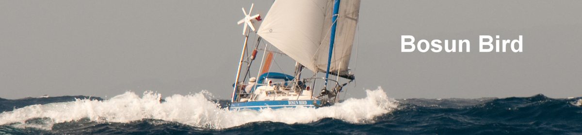
 D-Day was Tuesday September 6th, almost 20 years to the day after we set off from Maple Bay, British Columbia (Canada), on what was to become a circumnavigation (but in our first boat: Tarka the Otter). It was with some regrets that we motored down the Berg River, past the familiar old wooden fishing boats – Silver Katonkel, Stormkop, Loerisfontein – and into the open ocean but, objectively speaking, South Africa is no great place for recreational sailing. So few are the sheltered anchorages and so extreme and fast the weather changes that, as one cruising friend put it to us, “every time you tie up after a day-sail, it seems like a major achievement”.
Our first stop was to be Luderitz, Namibia: a 440-mile run up the West coast. With five metre swells still in evidence following the most recent storm, this was a rolly sail, the boom often grazing the rushing waters as we lurched from one side to the other and skidded diagonally down the face of the waves. Nick had taken the precaution of dosing up heavily on Stugeron, the only seasickness remedy that works for him (apart from sitting under a palm tree) so that, unlike off the coasts of Washington and Oregon twenty years earlier, he was able to contribute to the handling of the vessel.

 Winds were generally strong and the seas cold: all the way up this coast the Benguela current, surging up North from Antarctica, makes things a lot cooler (and foggier) than you would otherwise expect at these latitudes. The cockpit was rarely dry and we made maximum use of our new red (and expensive) foul weather gear. On our fourth and last night out the winds rose to gale force for several hours, forcing us to fly our smallest jib, which still kept us racing down the rollers at four knots.
") One bonus of the cold current was extraordinarily abundant bird life: until we were well over half way to St Helena we were rarely without three or four albatrosses wheeling in our wake, the tiny Wilson’s Storm Petrel dancing the foam of our bow wave, and Cape Petrels, all of which are normally considered Antarctic birds. The albatrosses are awe-inspiring to watch: for minutes on end, they have no need to beat their giant wings as they soar and dive, keeping their wingtip a bare centimetre or so above the breaking wave crests (Jenny thought they were just showing off…). Close to land we were also visited by curious Cape Fur Seals, escorted by dolphins and, one dark night, a whale startlingly exhaled and drew breath only a few metres away. Even when the stars were in (as they were most of the time) we left a trail of glittering phosphorescence, and some nights there would be strange and sudden flashes of light from beneath the sea, all around.
One bonus of the cold current was extraordinarily abundant bird life: until we were well over half way to St Helena we were rarely without three or four albatrosses wheeling in our wake, the tiny Wilson’s Storm Petrel dancing the foam of our bow wave, and Cape Petrels, all of which are normally considered Antarctic birds. The albatrosses are awe-inspiring to watch: for minutes on end, they have no need to beat their giant wings as they soar and dive, keeping their wingtip a bare centimetre or so above the breaking wave crests (Jenny thought they were just showing off…). Close to land we were also visited by curious Cape Fur Seals, escorted by dolphins and, one dark night, a whale startlingly exhaled and drew breath only a few metres away. Even when the stars were in (as they were most of the time) we left a trail of glittering phosphorescence, and some nights there would be strange and sudden flashes of light from beneath the sea, all around.
 We had bypassed Luderitz when we came this way in the eighties, on account of this coastline’s reputation as the Skeleton Coast, which is earned not just by its lack of shelter , but by the heavy fog, unpredictable inshore sets and the fact that vessels veering too far inshore are likely to be chased away from what is a designated “closed area” for diamond digging and dredging. However, our acquisition of a GPS (Geographical Positioning System) eliminated much of the previous uncertainty associated with landfalls hereabouts, and we made our landfall at Dias Point on schedule and in a fortuitous burst of sunshine.
 Luderitz is strange: a tiny outpost of Germany, with hundreds of kilometres of the Namib desert as its hinterland, just one road in and out, and no source of fresh water. It owes its existence to being the only good natural harbour Germany could use when this was a colony (before WW1) – Walvis Bay having been prudently pre-empted by Britain- and to diamonds. They were first discovered here at the turn of the 19th/20th century, and for the next fifty years this was the most important source of diamonds in the world, after Kimberley’s Great Hole. Still, many hundreds of square kilometres between Luderitz and the Orange River (the border with SA) are decreed as “Speergebiet” – a forbidden zone – by De Beers and the Government of Namibia. Most of the vessels in the harbour are connected with the offshore alluvial dredging operations that now provide most diamonds: giant barges known as “crawlers” that creep along slowly sucking up and filtering gravel from the sea bed, and smaller working boats with tell-tale 50m long vacuum hoses trailing in the water behind them.

We visited an eerie diamond ghost town at Kolmanskopp, where the sand dunes have invaded the ground floors of the once stately homes of the senior mangers, but where the Kasino (gentleman’s club) still has photos on the wall of amateur opera nights, of formal balls held under the eyes of the German imperial eagle, and of blonde young men performing gymnastic routines on the pommel horse that now gathers dust in the basement; there is a two-lane skittle alley that is still used occasionally; on the wall of one of the single men’s quarters is a drawing in charcoal of “Miss Kolmanskopp 1921”.

Out on a rocky headland 20km from today’s town is a replica of the “padrao”(stone cross) erected by Bartolomeo Dias in 1488 as a sign that he had come this way with his fleet of tiny caravels on the way to the Cape of Good Hope (which, on account of his travails all the way down this coast, he named Cape of Storms; Vasco de Gama laster decided this was bad PR and changed the name to Good Hope…); Dias named this bay Angra dos Ilheus (Bay of Islands). It was humbling to think that while we had fretted over our charts and GPS readings, wondering if Luderitz might be a little “iffy”, Dias had come this way totally blind, with no charts at all, no idea where he was going, against winds that were unrelentingly contrary, with an understandably mutinous crew and in vessels that could hardly do better than 90 degrees to the wind. Later distinguished visitors included the Russian Grand Fleet which bunkered here en route to catastrophe at Tsushima.

The Luderitz Yacht Club was friendly, letting us use a mooring, their hot showers and their landing beach; in their visitors’ book we found entries from March 1988 made by vessels and their crews whom we knew well; Pearl, from Vancouver; Kaap Bol from the Netherlands; Malulu from Australia. However, like many yacht clubs in such out of the way places, this seemed to be mainly a watering hole; and there didn’t seem to be too many non-white members. We stocked up once more on fresh vegetables, replenished our water tanks and, one week after our arrival, were on our way again, heading NW into the South Atlantic.
 In the 80s, the passage from the Cape to St Helena had been one of the favourites of our entire circumnavigation: a brisk start followed by gentle winds, some swimming when becalmed, ever warmer seas. But that was the end of summer; now we were at the tail end of a boisterous winter. Over the next two weeks we saw the sun only sporadically and wore our foul weather gear most of the time; only when we a mere 60 miles out from St Helena did a Bosun Bird spell off those Antarctic denizens. Day after day the wind blew at an uncomfortable 25 knots, building swells that again had us rolling heavily and dumping occasional dollops of cold water into the cockpit. Heading almost dead downwind meant we had constantly to tend our faithful but rather aged Wind Pilot, a Hasler-style self-steering gear – which involved leaning far out over the transom, the most mobile part of the vessel. Most nights we saw the lights of ships which, as always, made for some nervous moments as we attempted to figure out from the configuration of their lights whether or not they might be on a converging course; few would answer their radios when we called them up and most seemed slow moving, which led us to conclude they were fishing boats, likely Korean or Taiwanese (not noted for their strict adherence to international maritime regulations)
The highlight of every day was when we would mark up our position with a small cross on the chart (an enormous one with St Helena at the top, Tristan da Cunha in the middle, and – at the bottom, the remotest island in the world: Bouvetoya). Low points were getting up for those night watches, usually just as you had found a position in which you could doze off without rolling of your bunk.
 By now we hadn’t listened to the news or heard a cellphone tone for a month. Escapism? Maybe, but in some ways all this – the wind, the stars, the rushing ocean, seabirds, the emptiness – seems to us just as real and meaningful as the horrors of Iraq. One of the better books I read on this passage (there were many to which I would not admit.) was the inspiring if half-mad Kon Tiki Expedition.: in contemplative mode, Thor Heyerdahl writes: “Coal-black seas towered up on all sides and a glittering myriad of tropical stars drew a faint reflection from plankton in the water. The world was simple; stars and darkness. Whether it was 1947 AD or BC suddenly seemed of no significance…”
Thirteen days out the captain claimed the prize for the first sighting of land: the rugged, sheer outline of St Helena. But we were still 37 miles away, and there was no prospect of making the open roadstead off Jamestown, in the lee of the southeasters, before nightfall. We deliberately slowed down and, as night fell inched our way ever closer. There were one or two lights visible: occasionally one would become suddenly bright then fade – one of the island’s relatively few cars out for a Friday night party somewhere, catching us in his headlights from 20 miles away. With cloud settling low on the island, it took on a sinister prospect. And when we rounded the northeastern corner, below the cliffs of the aptly named “Barn”, we were hardly dazzled by the bright lights of Jamestown; perhaps a dozen white lights strung out on the shore, a weakly flashing light warning of a reef, a dense black mass filling most of our field of vision to the south. The place seemed lonely, tenuous, and we hadn’t even landed yet. The nearest human habitation was more than seven hundred nautical miles away: Ascension Island.
 For most of the night we nervously sailed ever so slowly back and forth some three miles offshore, anxious not to get blown away from the shelter of the island, but fearful lest we get too close to the unlit coast. It was with some relief that we got under way again at about 06:30 a.m. and motored to our anchorage; eighteen years earlier, we had never thought we would see this place again, but here we were. The 1366 mile run had taken us 14 days.
 Jamestown, the one and only significant settlement on St Helena, hadn’t changed much in 18 years. There were a lot more cars (one vehicle for every two of the island’s 5000 residents) but the Georgian High Street, reached across a moat and through a grand gate in the harbour wall, was intact: the Consulate Hotel, Wellington House, the covered market, and a rotunda-like building known as The Canister. HM Prison (2 cells) adjoined St James’ church, the oldest Anglican church in the southern hemisphere; in spite of the limited capacity of the prison and the extremely low crime rate (“Crime Report” on the radio usually consisted of appeals for young people not to litter the bus stop, and accounts of one or two speeding tickets issued) there were a dozen prison officers; government was by far the largest employer here. Most things were run from the 18th century buildings known as The Castle; outside, a parking space was reserved and marked “Gov”; apparently there was disappointment that the current incumbent declined to wear the traditional white uniform and plumed hat to which he was entitled.
 There were two shops: Thorpes and a Spar, both of which stocked South African and British imports. Although much of the island’s interior is fertile, landholdings are tiny and growers find it difficult to compete with imports: potatoes grown near Lambert’s Bay in SA, a few miles from our port of departure, were half the price of the local variety.
There was in 2005 no airport, which made this one of the most isolated communities in the world: ever since the island was first sighted and named in 1502, everything and everybody had come in and out by sea, landing at the same (quite dangerous) steps. An airfield was planned for 2010, but few seemed to believe this would really happen. The lifeline to the outside world, in the meantime, was the Royal Mail Ship St Helena (the last remaining vessel so designated in the wold), which carried up to 140 passengers and a goodish load of containers. It called about ten times a year, providing a service to Ascension, Walvis Bay and Cape Town, with maybe one or two trips a year to the UK; most islanders wishing to travel to Britain now took her to Ascension and then caught the weekly RAF plane to Brize Norton.
Many Saints had never left home; in fact it was only a year or two ago that they were given the right of abode in the UK. I wonder in how many places, today, would you still find people who have never strayed more than 6km from their home (the maximum possible distance here!), who have never seen an aircraft, a train or a traffic light? One lady we spoke on the quayside had been once to Cape Town, for two days, but said she spent most of her time – when she was not worrying about being robbed – just people-watching, wondering where everyone could be going, and why they seemed to be hurrying so. Another habitue of the quay was a toothless fellow in his eighties, a radio aficionado who knew all the provincial capitals of Canada and even the PM’s name, but who had never been off-island and professed no desire to do so.
 In spite of the tiny scale of the place – from barely a mile offshore you can see from one extremity of the island to the other – there was lots to see and do; the hills are rugged and the valleys between them so deep that just getting from one district to another can take hours; one joke has it that none of the cars actually have third and fourth gears, because nowhere is flat enough for you to need them. All around, especially along the coastline, is evidence of the role St Helena once played as a coaling station and for re-victualling ships holding the Empire together – standing, as it does, plumb on the direct sailing route from the Cape of Good Hope to the Channel: great crumbling fortifications at every conceivable landing place, and a fortress high on a crag called High Knoll that was refurbished as late as the eighteen-fifties with the aim of providing the population with “safe refuge in case of invasion” (by whom??).
When Charles Darwin was here in 1836, at the conclusion of his five years aboard HMS Beagle, he remarked a little sourly “the first circumstance which strikes one is the number of roads and forts: the labour bestowed on the public works seems out of all proportion to its extent or value..”. Many of these fortifications were constructed or beefed up on account of St Helena’s most famous one-time resident, Napoleon, who was imprisoned here after his defeat at Waterloo until his death in 1821. But one suspects the islanders are a little tired of hearing about him; still in acerbic mood, Darwin noted “after the volumes of eloquence which have poured forth on this subject, it is dangerous for me even to mention Napoleon’s tomb”.
 You can visit The Briars, the small country house overlooking Jamestown where the Emperor spent his first month or so. A nicely polished brass plaque, however, gives equal pride of place to another temporary resident of the The Briars who had stayed here a night or two several years previously, Arthur Wellesley, later the Duke of Wellington; perhaps Napoleon did not appreciate this irony. And on a cool and misty plateau in the centre of the island is his longer-term home, Longwood, outside which the tricolour flies and which is maintained by the French government. Here you can see the large billiard table on which Napoleon spread out his campaign maps while dictating his memoirs to his faithful secretary, idly rolling a billiard ball from one side to another; the deep iron bathtub in which he spent hours reading and soothing his ulcers; the peepholes he cut in the shutters to observe his guards and – of course – the bed in which he died.
Our guide had no time for Sir Hudson Lowe, the then-governor and Napoleon’s de facto gaoler, who inhabited the more salubrious and grand Plantation House, but he did not believe Napoleon had been wilfully poisoned; the arsenic found in his hair when he was exhumed in 1840 and removed to Les Invalides was most likely a product of the damp wallpaper, it seems.
 Meanwhile, over at Plantation House, the present Governor was not receiving but we did meet the five other beings with whom he shares his grounds: Jonathan, David, Myrtle, Fredericka and Speedy. They are all very large Seychelles tortoises. Jonathan was brought here in 1880, at which time he was recorded as being “mature”; in the tortoise wold, this means over-50, which now made him over 170. While he wasn’t exactly sprinting around the lawn, he did move at least 100ft over the two hours or so we were in the area; and the green paint on his carapace was the same shade as on the garden fencing, which suggests that once he had even made an escape bid.
We went for several long walks in the hills, found the Boer POW camp and cemetery, poked our noses into rural churches and chatted with the locals, who had an old-style courtesy we had only encountered in one other place: Ireland. Unusually, there were no other yachts in harbour, so the traditional yachtie hangout, Anne’s Place, was quiet; but we left an entry in her log book and retrieved the volume including March 1988,with half a page written by the crew of Tarka the Otter. Reluctantly, but we had no choice, we traded some of the not-so-bad paperbacks we had read en route from SA for Danielle Steele and Rosamunde Pilcher.
We were shocked to hear one day on the local news that a yacht bound for St Helena from Cape Town, the Nautigal, had foundered in heavy weather with the loss of two of her three crew only ten miles out of Cape Town; it seemed that winter was still biting in the Cape.
The anchorage at Jamestown (actually a deep water, open and very rolly expanse that would not normally merit such a name), was enlivened during our stay by the arrival of the St Helena (the “RMS” as everyone called her). We were asked to move so as to permit the unencumbered passage of lighters; conveniently, a departing French fishing boat offered us his deep water mooring. For the best part of three days there were constant comings and goings and it was interesting to watch the skillful unloading operations: in an ever-present heavy swell containers were lowered one by one onto small barges which were then towed ashore, to be hoisted ashore once again in an equally sensitive operation. For passengers there was a launch service, but the nervous, aged or infirm could avail themselves of the “air taxi” – a kind of cage with two seats in it which was hoisted on to and off the barge by cranes; it seemed to us a lot more scary, not to say embarrassing, than risking the swell at the steps.
It was a busy 12 days in St Helena, but the next wide open space on the chart – 2170 nautical miles to Rio de Janeiro – beckoned, so on Thursday October 13th we were off again.
Like Joshua Slocum (the first single-handed circumnavigator, who passed this way in 1898) we were sad to leave and the first night seemed lonely: “…I watched the beacon light at Plantation House, the governor’s parting signal for the Spray, till the island faded in the darkness astern and became one with the night, and by midnight the light itself had disappeared below the horizon.”
 This was another quite fast and windy passage but, unlike on the way to St Helena, we finally did have some long periods of blue sky and warm weather – even though were sailing south from St Helena’s 15 degrees of latitude to Rio’s 22. The steady weather meant we could listen to the CD portable player at night (“Evita” in preparation for Argentina), and once a day to the news on the BBC (although this was rarely an uplifting experience); we also started to pick up Brazilian AM radio stations from as far as 1500 miles out. We fished for most of the way but caught exactly nothing; instead we had to reel in the line a couple of times when oceanic birds displayed interest in the lure. Several mornings we awoke to find flying fish stranded on deck, one a good foot long; watching them shoot out of the front of a wave and zooming over the surface for fifty metres or more, you appreciate why the French name for their deadly anti-ship missiles, “exocet”, was so apt.
 The only landmarks on this voyage were the oceanic islands of Martin Vaz and Trinidade, Brazilian possessions but over 750 miles offshore; the latter has a small military detachment but the former is uninhabited. We passed about 25 miles south of them and had them in view most of the day: Trinidade is some 700 metres high. Then, still 200 miles or so out, we skirted a large area of offshore oil drilling. It was quite eerie at night, with enormous gas flares reflecting off the cloud bases and creating an apocalyptic mood; more practically, there were lots of ships around, so we had to keep a particularly good watch.
 After Trinidade the dependable trade winds (southeast and east) faded and we had several days of strong northwesters, which meant we were hard on the wind and things got quite wet; there were also constant squalls, which made for sudden Chinese fire drills in the middle of the night as we rushed to take sail down, or put it up again once the squalls had passed. The unsettled weather culminated in a very strong blow – about Force 8 – some 24 hours out from the coast: this had us surging along downwind, at five or six knots, with about two square metres of sail up, spray from the wave tops whipping into us from astern and the occasional large dollop crashing aboard; the phrase “whiteknuckle sailing” applies literally in these conditions as you wrestle with the tiller (I was hand steering by now); the good news was that the water was at least warm. But the same afternoon the distinctive outline of Cabo Frio came into view and the final seventy miles West along the Brazilian coast to the entrance of Guanabara Bay were much more tranquil.
 Entering Rio harbour at dawn, after 22 days at sea was an experience not to be forgotten. Behind us the rising sun created all sorts of spectacular effects on the unsettled eastern sky, while in front there steadily grew the famous outline of the Sugarloaf with, behind it, the sharper peak that is the Corcovado, its huge statue of Christ illuminated a pale blue; then the sun hit the skyscrapers and the luxury hotels on Copacabana and Ipanema beaches. Unfortunately, though, the entry was not as relaxed as it might have been. As the wind died we cranked up the engine. But an ominous burning smell was soon evident… We immediately switched off and rolled rather uneasily in the swell, about a mile offshore, as the captain wrestled to push back into place the water pump shaft, which had worked loose and bored an impressively neat hole in the wooden engine cover. Following this, the crew was designated to stay below and watch the shaft attentively as we negotiated the final entry to the harbour, including crossing the busy shipping lanes.
But by mid-morning we were safely anchored in Urca Bay, at the very foot of the Sugarloaf. While the South Atlantic would certainly have many more (harder) tests in store for us, our second crossing of this great ocean was now successfully behind us.
More: Brazil and Patagonia